Data
- Obtaining
- Supplying
- High-Frequency
- Bottom Pressure Records
- Other Long Records
- GLOSS/ODINAFRICA Calibration Data
Donate
Donate to PSMSL
Data Notes
- Individual Station Data and Plot Notes
- Referencing the Data Set
- PSMSL Help File
- 2010 Changes to the PSMSL Data Files
Extracted from Database
20 Jul 2026
Station Information
| Station ID: | 460 |
| Latitude: | 40.533333 |
| Longitude: | 141.533333 |
| Coastline code: | 642 |
| Station code: | 1 |
| Country: | JAPAN |
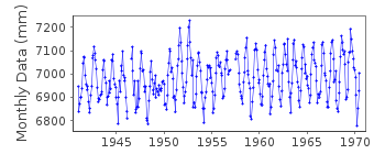
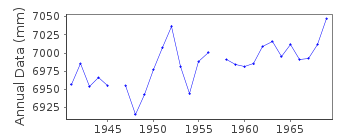
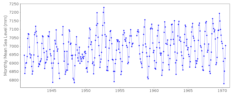
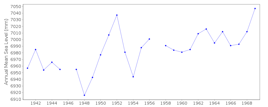
| Time span of data: | 1941 – 1970 |
| Completeness (%): | 96 |
| Date of last update: | 01 Jan 1980 |
| Green Arrow: | Current Station |
| Yellow Marker: | Neighbouring RLR Station |
| Red Marker: | Neighbouring Metric Station |
Please note: In many cases, the station position in our database is accurate to only one minute. Thus, the tide gauge may not appear to be on the coast.
Tide Gauge Data
Additional Data Sources (guide to additional data sources)
Research Quality Data from UHSLC station 375: hourly and dailyStation Documentation
Link to RLR information.Documentation - date unknown
Station moved - new data held in station 642/002Documentation added 1991-06-11
Hachinohe I 642/001 RLR(1969) is 11.7m below Attached BMDocumentation added 1993-07-12
Hachinohe I 642/001 RLR(1969) is 11.7m below Attached BMDocumentation added 2002-03-26
Hachinohe I ceased operating July 31st 1970, replaced by Hachinohe IIAugust 3rd 1970.
Data Authority
Japan Meteorological Agency3-6-9 Toranomon, Minato City
Tokyo

![]()
![]()
![]()
