Data
- Obtaining
- Supplying
- High-Frequency
- Bottom Pressure Records
- Other Long Records
- GLOSS/ODINAFRICA Calibration Data
Donate
Donate to PSMSL
Data Notes
- Individual Station Data and Plot Notes
- Referencing the Data Set
- PSMSL Help File
- 2010 Changes to the PSMSL Data Files
Extracted from Database
13 Jul 2026
Station Information
| Station ID: | 457 |
| Latitude: | 47.27 |
| Longitude: | -2.2 |
| Coastline code: | 190 |
| Station code: | 111 |
| Country: | FRANCE |
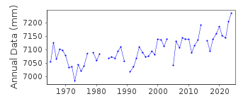
| Time span of data: | 1941 – 2025 |
| Completeness (%): | 69 |
| Link to ellipsoid: | Available |
| Date of last update: | 20 Feb 2026 |
| Green Arrow: | Current Station |
| Yellow Marker: | Neighbouring RLR Station |
| Red Marker: | Neighbouring Metric Station |
Please note: In many cases, the station position in our database is accurate to only one minute. Thus, the tide gauge may not appear to be on the coast.
Tide Gauge Data

Additional Data Sources (guide to additional data sources)
Nearby GNSS Stations from SONEL: STNZ, STNANearby Real Time Stations from VLIZ: sain2, sain
Station Documentation
Link to RLR information.Documentation - date unknown
1941-1942 DATA SUPPLIED BY AUTHORITY NO. 66Documentation added 1991-06-11
St Nazaire 190/111 RLR(1974) is 11.9m below BM NGFN.45Documentation added 1993-07-12
St Nazaire 190/111 RLR(1974) is 11.9m below BM NGFN.45Documentation added 2010-08-25
New primary benchmark IGN "NGF" OKS 69 was installed in 1990 8.852m above the then Chart Datum. In 1996 the value for Chart Datum was lowered by 0.4m. So new benchmark IGN"NGF" OKS 69 now 9.252m above the new Chart Datum.
RLR factor for data 1941-1996 is 3.905m. RLR factor for data 1996 onwards is
3.505m. RLR (1974) is 12.757m below TGBM IGN "NGF" OKS 69
Documentation added 2014-10-02
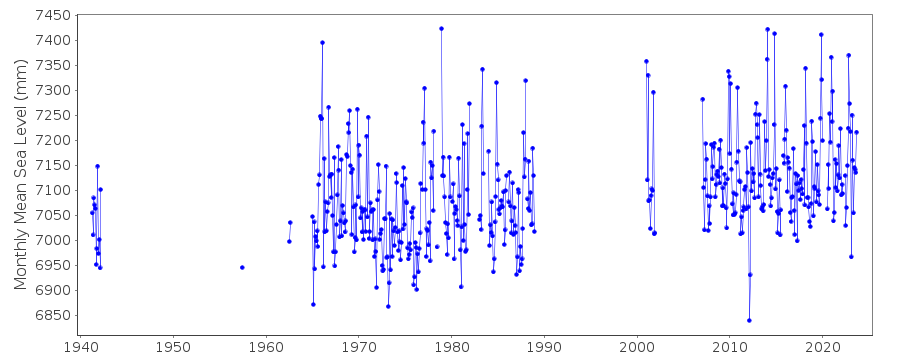
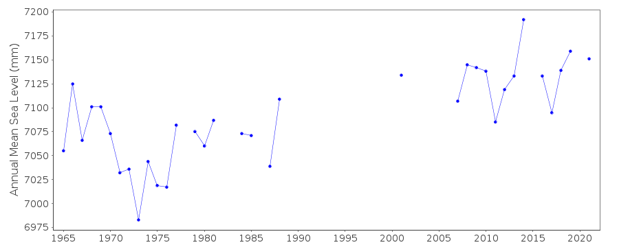
Using data from SONEL the latitude and longitude for St. Nazaire has been updated. The data downloaded from SONEL contained a number of additional and revised data points particularly around the early 2000's. Because of this the whole dataset was reloaded onto the database. This revised dataset had been adjusted to the same datum. With the revision to the dataset data values for 1943 onwards now have the RLR factor 3.505m.Documentation added 2025-07-15
Updated the whole dataset to ensure they include all the historical data recovered recently by SHOM and the calculated monthly and annual means match those distributed by SONEL.Data Authority
SHOM13 rue de Chatelier
29200 BREST

![]()
![]()
![]()
