Data
- Obtaining
- Supplying
- High-Frequency
- Bottom Pressure Records
- Other Long Records
- GLOSS/ODINAFRICA Calibration Data
Donate
Donate to PSMSL
Data Notes
- Individual Station Data and Plot Notes
- Referencing the Data Set
- PSMSL Help File
- 2010 Changes to the PSMSL Data Files
Extracted from Database
13 Jul 2026
Station Information
| Station ID: | 456 |
| Latitude: | 3.9 |
| Longitude: | -77.1 |
| GLOSS ID: | 170 |
| Coastline code: | 842 |
| Station code: | 11 |
| Country: | COLOMBIA |
| Time span of RLR data: | 1941 – 1969 |
| RLR completeness (%): | 91 |
| Time span of metric data: | 1941 – 2014 |
| Metric completeness (%): | 90 |
| Date of last update: | 04 Nov 2015 |
| Green Arrow: | Current Station |
| Yellow Marker: | Neighbouring RLR Station |
| Red Marker: | Neighbouring Metric Station |
Please note: In many cases, the station position in our database is accurate to only one minute. Thus, the tide gauge may not appear to be on the coast.
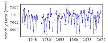
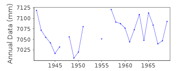
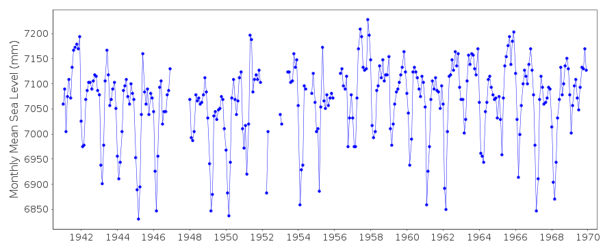
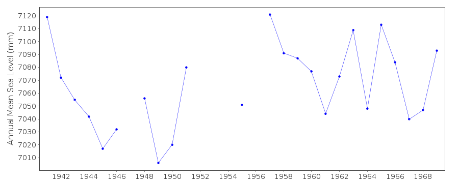
Tide Gauge Data
Additional Data Sources (guide to additional data sources)
Nearby GNSS Stations from SONEL: BUENNearby Real Time Stations from VLIZ: buve2, buve3
Research Quality Data from UHSLC station 85: hourly and daily
Station Documentation
Link to RLR information.Documentation added 1991-06-11
Buenaventura 842/011 RLR(1964) is 11.9m below BM2Documentation added 1993-04-19
The Colombian earthquake of 12 December 1979 caused the coast around Tumaco (station code 842/021) to subside up to 1.6m - see Herd et al. 1979, Science, 211, 441-445. PRIOR TO 1970 DATA SUPPLIED BY AUTHORITY CODE NO. 52 1973 - DATUM CHANGE MID-YEAR WHEN GAUGE RE-SITED, VALUES SEEM QUESTIONABLEDATA PRIOR TO 1985 RECEIVED FROM AUTHORITY A7
Documentation added 1994-04-20
1992: Jan- July and December data from digital gauge, Aug-Nov from Fuess gaugeDocumentation added 1994-04-20
1993 Jan-Aug data from digital gauge, Sept-Nov from Fuess gaugeDocumentation added 2004-10-05
data for 1997 on received from University of Hawaii Sea Level CenterDocumentation added 2012-01-18
Using data from the latest UHSLC JASL cd the 'METRIC' dataset has been updated.Data values for 2001-2011 have been added to the dataset.Documentation added 2015-11-04
Updated JASL data for 2011-2014 has been added to the 'Metric' plot.Data Authority
I.D.E.A.M.Carrera 5a, No.15-80 Piso 18
Aa 18633 Santafe de Bogota Dc

![]()
![]()
![]()
