Data
- Obtaining
- Supplying
- High-Frequency
- Bottom Pressure Records
- Other Long Records
- GLOSS/ODINAFRICA Calibration Data
Donate
Donate to PSMSL
Data Notes
- Individual Station Data and Plot Notes
- Referencing the Data Set
- PSMSL Help File
- 2010 Changes to the PSMSL Data Files
Extracted from Database
13 Jul 2026
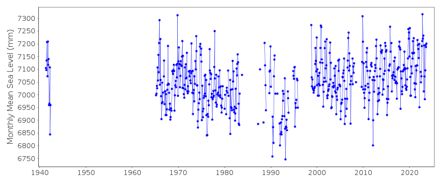
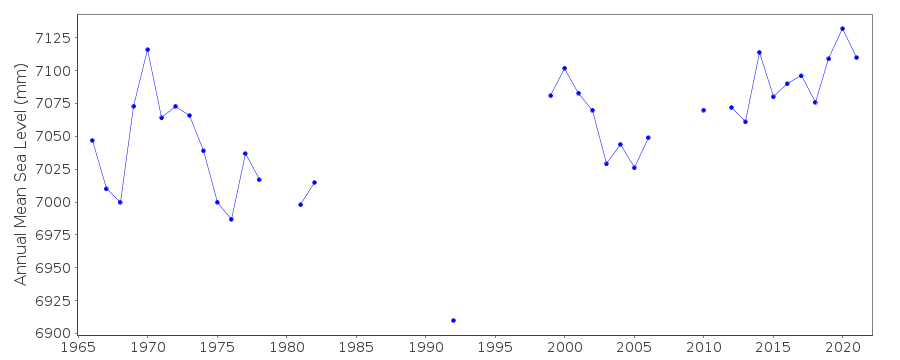
Station Information
| Station ID: | 455 |
| Latitude: | 50.969399 |
| Longitude: | 1.86772 |
| Coastline code: | 190 |
| Station code: | 11 |
| Country: | FRANCE |
| Time span of data: | 1941 – 2025 |
| Completeness (%): | 56 |
| Date of last update: | 20 Feb 2026 |
| Green Arrow: | Current Station |
| Yellow Marker: | Neighbouring RLR Station |
| Red Marker: | Neighbouring Metric Station |
Please note: In many cases, the station position in our database is accurate to only one minute. Thus, the tide gauge may not appear to be on the coast.
Tide Gauge Data
Additional Data Sources (guide to additional data sources)
Nearby Real Time Stations from VLIZ: cala2, calaStation Documentation
Link to RLR information.Documentation - date unknown
1941-1942 DATA SUPPLIED BY AUTH. CODE 66Documentation added 1991-06-11
Calais 190/011 RLR(1975) is 12.7m below BMNGFNAL3.44(1981)Documentation added 1994-10-21
December 1990-November 1991 no data availableDocumentation added 1994-11-21
1984-1991 data unavailable because of poor qualityDocumentation added 1999-09-09
no observations since November 1995Documentation added 2001-12-06
Calais new acoustic gauge installed 8/11/1998 at 5058N 00152E (prev. 00151E). Acoustic gauge replaced by radar (Krohne BM70)gauge 23/4/2001. RLR redefined 6/12/2001 to different (more stable) benchmark. Calais RLR(1975) is 12.51m below BM NA L3.43aDocumentation added 2011-02-02
From information on the SHOM and SONEL websites the RLR diagram for Calais has been updated. Primary benchmark is now N.A.L.3 - 159. Datum remains the same so RLR unchanged.Documentation added 2014-09-29
When downloaded from SONEL additional data points have been added for 1987-90. The whole dataset has been loaded to include these.Documentation added 2016-06-21
When loading the 2015 dataset it was noted that data points for September-November 2011 and February 2012 had been revised.Documentation added 2025-07-15
Updated the whole dataset to ensure they include all the historical data recovered recently by SHOM and the calculated monthly and annual means match those distributed by SONEL.Data Authority
SHOM13 rue de Chatelier
29200 BREST

![]()
![]()
![]()
