Data
- Obtaining
- Supplying
- High-Frequency
- Bottom Pressure Records
- Other Long Records
- GLOSS/ODINAFRICA Calibration Data
Donate
Donate to PSMSL
Data Notes
- Individual Station Data and Plot Notes
- Referencing the Data Set
- PSMSL Help File
- 2010 Changes to the PSMSL Data Files
Extracted from Database
20 Jul 2026
WARNING: QCFLAG EXISTS. PLEASE READ THE DOCUMENTATION.
Station Information
| Station ID: | 444 |
| Latitude: | 13.55 |
| Longitude: | 100.583333 |
| Coastline code: | 600 |
| Station code: | 41 |
| Country: | THAILAND |
| Time span of data: | 1940 – 2024 |
| Completeness (%): | 96 |
| Date of last update: | 04 Aug 2025 |
| Green Arrow: | Current Station |
| Yellow Marker: | Neighbouring RLR Station |
| Red Marker: | Neighbouring Metric Station |
Please note: In many cases, the station position in our database is accurate to only one minute. Thus, the tide gauge may not appear to be on the coast.
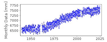
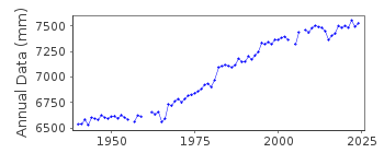
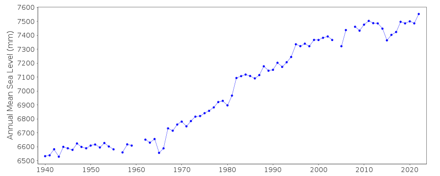
Tide Gauge Data
Station Documentation
Link to RLR information.Documentation added 1991-06-11
Fort Phrachula Chomklao 600/041 RLR(1981) is 8.4m below BM PJ2Documentation added 1993-07-12
Sharp increase of trend after data gap in early 1960s.Documentation added 1994-07-05
Same as Pom PhrachunDocumentation added 1994-07-14
For a discussion of submergence near to Fort Phrachula Chomklao see Emery and Aubrey (Sea Levels, Land Levels and Tide Gauges), 1991, Springer-Verlag, pages 35-36 and 100.Documentation added 2006-11-28
2005 data flagged suspect. Data looks way out - authority contacted to confirm datum etc. of data.Documentation added 2008-09-08
There is what appears to be a datum shift from 2003 onwards. Following levelling carried out at site the Authority has said that the offset for the data is 0.583m. When this was added to the relevant data the plot appears to be acceptable. The previous flags were removed from the individual data points as the station itself is flagged. However, the data must still be used with caution.Documentation added 2011-07-12
While researching datum and benchmark information prior to uploading the RLR diagram onto the website it was noted that the bench mark from 1987 onwards changes from BM PJ2 4.41m above the gauge datum to BM 1 5.826m above the datum. The datum remains the same.Documentation added 2017-08-30
Using datum information supplied the RLR diagram has been updated. Primary benchmark is B.M. 1 (MARINE SURVEY DIVISION)Data Authority
Oceanographic DivisionHydrographic Department
Royal Thai Navy
222 Rimtang-Rodfai-kao Road
Bangna, Bangkok 10260

![]()
![]()
![]()
