Data
- Obtaining
- Supplying
- High-Frequency
- Bottom Pressure Records
- Other Long Records
- GLOSS/ODINAFRICA Calibration Data
Donate
Donate to PSMSL
Data Notes
- Individual Station Data and Plot Notes
- Referencing the Data Set
- PSMSL Help File
- 2010 Changes to the PSMSL Data Files
Extracted from Database
13 Jul 2026
Station Information
| Station ID: | 43 |
| Latitude: | 18.916667 |
| Longitude: | 72.833333 |
| Coastline code: | 500 |
| Station code: | 41 |
| Country: | INDIA |
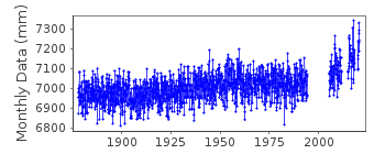
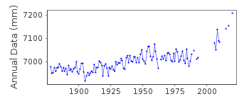
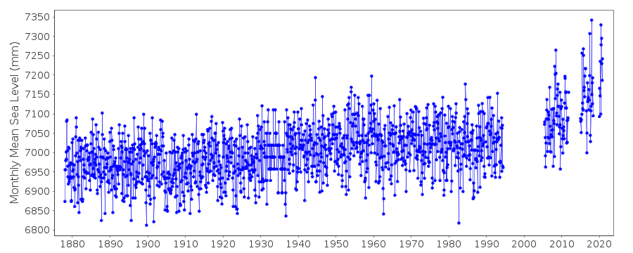
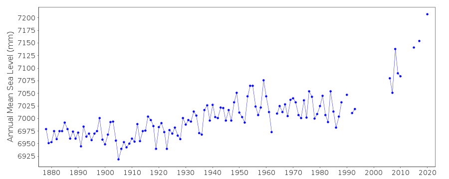
| Time span of data: | 1878 – 2024 |
| Completeness (%): | 88 |
| MTL Data: | 1931-1958 |
| MTL-MSL (mm): | 31 |
| Date of last update: | 02 Feb 2026 |
| Green Arrow: | Current Station |
| Yellow Marker: | Neighbouring RLR Station |
| Red Marker: | Neighbouring Metric Station |
Please note: In many cases, the station position in our database is accurate to only one minute. Thus, the tide gauge may not appear to be on the coast.
Tide Gauge Data
Station Documentation
Link to RLR information.Documentation - date unknown
1931 - 1958 values based on readings of high and low waters.Documentation added 1991-06-11
Bombay (Apollo B) 500/041 RLR(1964) is 13.0m below BM 2(PP)(1)Documentation added 1994-08-04
For a discussion of interannual variability of sea level along the coasts of Pakistan and India, see Clarke and Liu, Journal of Physical Oceanography, 24, 1224, 1994.Documentation added 2002-12-06
SMRC Newsletter Jul-Dec 2001 reports high E coast correlation with SOI and MSL. MSL is much higher during La Nina tropical cyclones than during El Nino.Documentation added 2009-04-15
Benchmark and datum details for 2005/6 remain the same as previously so the same RLRFAC was used.Documentation added 2010-09-16
Benchmark for the historic data up to 1965 was BM 2PP1 up to 1936 the datum was 9.132m below this benchmark. For data 1937 onwards the datum was 'Chart Datum' with BM 2PP1 being 8.522m above this. In 1966 the benchmark was changed to BM 5/88 7.44m above chart datum.Documentation added 2014-06-23
Please Note that the monthly mean sea level values for the period 1931 to 1936 were reported only to the nearest tenth of a foot, approximately 30mm. This explains the appearance of discrete sampling in height of the sea level variation during this time.Documentation added 2016-01-12
We have changed the first line above, indicating that the MTL ends in 1958, not 1956 as was previously stated. We have verified that the values in the database are those from Pub. Sci. 20, in which they were indicated as MTL.Documentation added 2016-01-22
A value of MTL-MSL=31 mm has been applied to the RLR data for the period 1931-1958. This value was derived from the average of three differences in the annual MSL and MTL listed in Pub. Sci. 24. Note that no correction has been applied to the metric data.Documentation added 2018-11-01
Following a check on the new database several stations were reviewed. As a result both the RLR diagram and the RLR factor could have changed.Documentation added 2020-02-05
There is no data for Mumbai for 2012 to 2014 due to non-function of the tide gauge.Data Authority
Survey of IndiaGeodetic and Research Branch
17 E.C. Road
Dehra Dun
PIN 248 001

![]()
![]()
![]()
