Data
- Obtaining
- Supplying
- High-Frequency
- Bottom Pressure Records
- Other Long Records
- GLOSS/ODINAFRICA Calibration Data
Donate
Donate to PSMSL
Data Notes
- Individual Station Data and Plot Notes
- Referencing the Data Set
- PSMSL Help File
- 2010 Changes to the PSMSL Data Files
Extracted from Database
13 Jul 2026
Station Information
| Station ID: | 410 |
| Latitude: | 38.959078 |
| Longitude: | 20.756628 |
| Coastline code: | 290 |
| Station code: | 1 |
| Country: | GREECE |
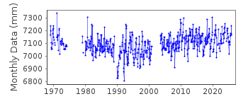
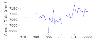
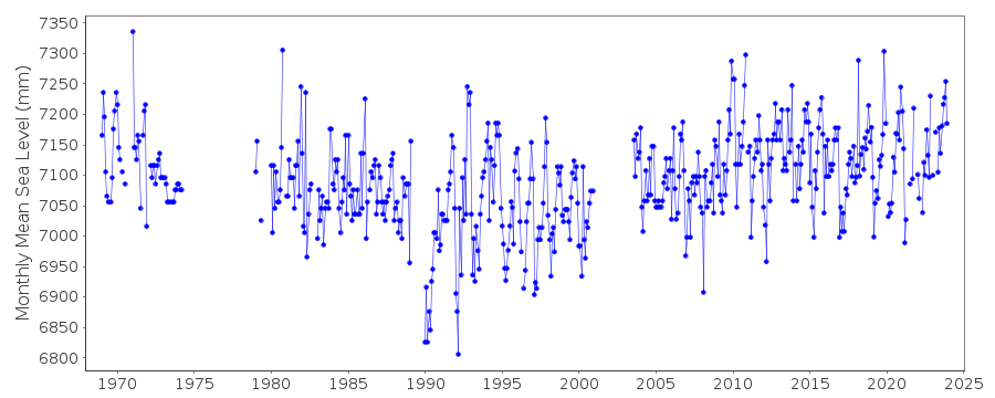
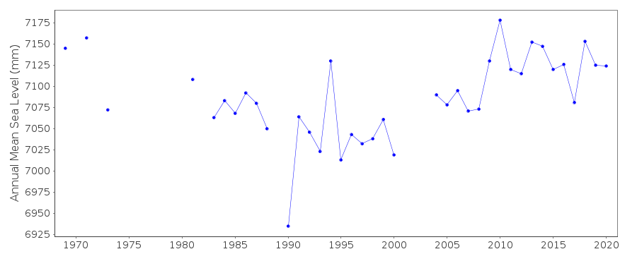
| Time span of RLR data: | 1969 – 2025 |
| RLR completeness (%): | 79 |
| Time span of metric data: | 1937 – 2025 |
| Metric completeness (%): | 53 |
| Date of last update: | 13 Mar 2026 |
| Green Arrow: | Current Station |
| Yellow Marker: | Neighbouring RLR Station |
| Red Marker: | Neighbouring Metric Station |
Please note: In many cases, the station position in our database is accurate to only one minute. Thus, the tide gauge may not appear to be on the coast.
Tide Gauge Data
Additional Data Sources (guide to additional data sources)
Nearby Real Time Stations from VLIZ: prevStation Documentation
Link to RLR information.Documentation - date unknown
1969-74 Data from readings of tide poleDocumentation added 1991-06-11
Preveza 290/001 RLR(1981) is 9.3m below BM R87Documentation added 1993-07-12
Preveza 290/001 RLR(1981) is 9.3m below BM R87Documentation added 1997-03-11
The contributing authority advises that anomalous valuesare the result of met. influences
Documentation added 2009-01-28
Treat data 1990 to 1992 as susupect.Documentation added 2010-03-04
There has been some confusion with the Greekstations as they change from recording the
sea level height downwards to the more
conventional upwards measurement. For this
reason 2008 for Preveza was not entered
with the rest of the 2008 data. However when
2009 added the dataset looks OK. RLR has been
re-instated.
Documentation added 2013-10-07
Using values supplied by the Hellenic Navy the RLR diagram has been redrawn. The previous Primarty benchmark R 87 no longer features in the hellenic Navy figures.an alternative benchmark R137 has been chosen as the Primary benchmark.Data Authority
Hellenic Navy Hydrographic ServiceGeographic Policy and International Relations Office
TGN 1040
Athens

![]()
![]()
![]()
