Data
- Obtaining
- Supplying
- High-Frequency
- Bottom Pressure Records
- Other Long Records
- GLOSS/ODINAFRICA Calibration Data
Donate
Donate to PSMSL
Data Notes
- Individual Station Data and Plot Notes
- Referencing the Data Set
- PSMSL Help File
- 2010 Changes to the PSMSL Data Files
Extracted from Database
13 Jul 2026
Station Information
| Station ID: | 409 |
| Latitude: | 37.951156 |
| Longitude: | 22.9601 |
| Coastline code: | 290 |
| Station code: | 11 |
| Country: | GREECE |
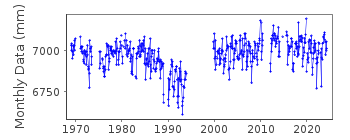
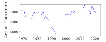
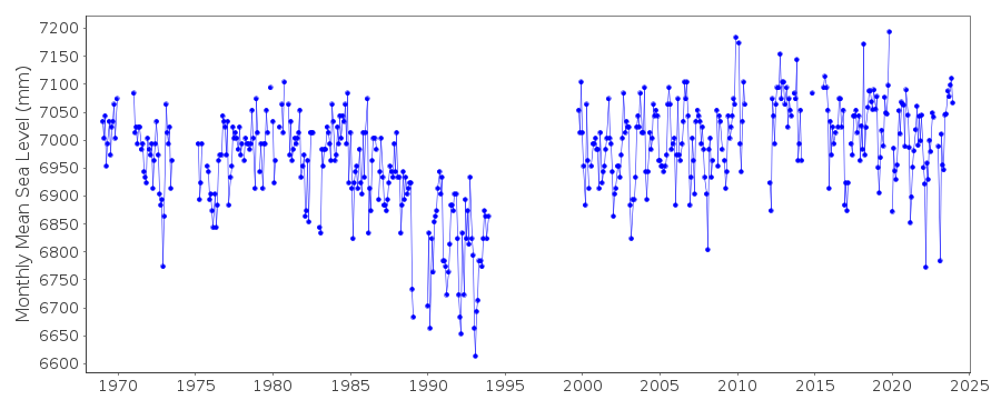
| Time span of RLR data: | 1969 – 2024 |
| RLR completeness (%): | 73 |
| Time span of metric data: | 1937 – 2024 |
| Metric completeness (%): | 51 |
| Date of last update: | 16 Apr 2025 |
| Green Arrow: | Current Station |
| Yellow Marker: | Neighbouring RLR Station |
| Red Marker: | Neighbouring Metric Station |
Please note: In many cases, the station position in our database is accurate to only one minute. Thus, the tide gauge may not appear to be on the coast.
Tide Gauge Data
Additional Data Sources (guide to additional data sources)
Nearby GNSS Stations from SONEL: KORINearby Real Time Stations from VLIZ: corn1
Station Documentation
Link to RLR information.Documentation - date unknown
1969-1973 Data from readings of tide poleDocumentation added 1991-06-11
Posidhonia 290/011 RLR(1981) is 8.6m below BM R67Documentation added 1997-03-11
The contributing authority advises that anomalous values are the result of met. influencesDocumentation added 2000-06-14
Posidonia tide gauge malfunctioned 1994, repaired in 1999. Data for 1994-6 deleted from database.Documentation added 2001-05-14
Data for 1999 onwards looks approx 0.3 m higher than pre-1994 data. HNHS state that the gauge is operating normally and so it is assumed that no datum change has occurred.Documentation added 2006-11-28
Station flagged and switched from RLR to 'Metric' because of datum anomaly.Documentation added 2011-03-03
After a review of the dataset it was decided that the data for October 1999-December 2002 be revised to RLR. Data for the period January 2003 onwards when the method of data measured was changed has been relegated to 'Metric'. However the station has been reinstated as RLR so that the 'good' RLR data is visible on the website. The station remains flagged.Documentation added 2011-07-13
Following further information from the Hellenic Navy Oceanography Service a datum adjustment was applied to the data for 2003 onwards. When plotted the data now appears correct. RLR status has been reinstated and the station flag removed.Documentation added 2013-08-07
Following receipt of datum diagrams from the Hellenic Navy the RLR diagram has been re-drawn. In consequence both the RLR factors and the benchmark reference have changed.Data Authority
Hellenic Navy Hydrographic ServiceGeographic Policy and International Relations Office
TGN 1040
Athens

![]()
![]()
![]()
