Data
- Obtaining
- Supplying
- High-Frequency
- Bottom Pressure Records
- Other Long Records
- GLOSS/ODINAFRICA Calibration Data
Donate
Donate to PSMSL
Data Notes
- Individual Station Data and Plot Notes
- Referencing the Data Set
- PSMSL Help File
- 2010 Changes to the PSMSL Data Files
Extracted from Database
13 Jul 2026
Station Information
| Station ID: | 394 |
| Latitude: | 10.3 |
| Longitude: | 123.916667 |
| Coastline code: | 660 |
| Station code: | 101 |
| Country: | PHILIPPINES |
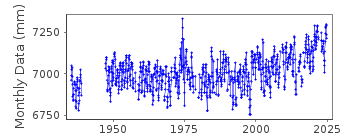
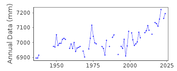
| Time span of data: | 1935 – 2024 |
| Completeness (%): | 80 |
| Date of last update: | 18 Jun 2025 |
| Green Arrow: | Current Station |
| Yellow Marker: | Neighbouring RLR Station |
| Red Marker: | Neighbouring Metric Station |
Please note: In many cases, the station position in our database is accurate to only one minute. Thus, the tide gauge may not appear to be on the coast.
Tide Gauge Data
Additional Data Sources (guide to additional data sources)
Research Quality Data from UHSLC station 379: hourly and dailyStation Documentation
Link to RLR information.Documentation added 1991-06-11
Cebu 660/101 RLR(1966) is 9.1m below BM6Documentation added 1999-03-30
gauge type = OttDocumentation added 2010-10-14
Primary benchmark up to 2000 is BM6 3.839m above TSO 1935. For 2001 onwards Primary benchmark is BM 3A 4.708m above datum TSO 1935. RLR year is 1966 and RLR factor is 5.247m. RLR (1966) is 9.1m below BM 3A.Documentation added 2012-02-27
Cebu has been 'buddy checked' with Surigao. Cebu has what appears to be suspect data for the period Aug 1973-Feb 1975 and again Dec 1997-Dec 1999. Data for Surigao does not start until May 1987 but there is a similar sea level profile for the period Dec 1997-Dec 1999. Because of this the data has not been flagged. Gauge type is AXSYSData Authority
National Mapping and Resource Information AuthorityHydrography Department
421 Barraca St,
San Nicolas 1010
Manila

![]()
![]()
![]()
