Data
- Obtaining
- Supplying
- High-Frequency
- Bottom Pressure Records
- Other Long Records
- GLOSS/ODINAFRICA Calibration Data
Donate
Donate to PSMSL
Data Notes
- Individual Station Data and Plot Notes
- Referencing the Data Set
- PSMSL Help File
- 2010 Changes to the PSMSL Data Files
Extracted from Database
13 Jul 2026
WARNING: QCFLAG EXISTS. PLEASE READ THE DOCUMENTATION.
Station Information
| Station ID: | 380 |
| Latitude: | 38.65 |
| Longitude: | -27.233333 |
| Coastline code: | 360 |
| Station code: | 11 |
| Country: | PORTUGAL |
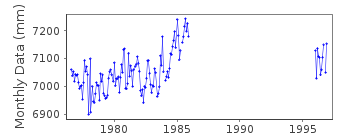
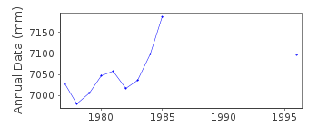
| Time span of RLR data: | 1976 – 1996 |
| RLR completeness (%): | 48 |
| Time span of metric data: | 1933 – 1996 |
| Metric completeness (%): | 51 |
| Date of last update: | 04 Nov 1998 |
| Green Arrow: | Current Station |
| Yellow Marker: | Neighbouring RLR Station |
| Red Marker: | Neighbouring Metric Station |
Please note: In many cases, the station position in our database is accurate to only one minute. Thus, the tide gauge may not appear to be on the coast.
Tide Gauge Data
Additional Data Sources (guide to additional data sources)
Nearby GNSS Stations from SONEL: TERCResearch Quality Data from UHSLC station 215: hourly and daily
Station Documentation
Link to RLR information.Documentation - date unknown
Prior to 1976 data supplied by the National Institute of Meteorology and Geophysics, LisbonDocumentation added 1991-06-11
Angra do Herismo 360/011 RLR(1979) is 11.5m below TGBMDocumentation added 1993-07-12
RLR record appears to suggest an increasing trend.Documentation added 1998-11-04
Data for 1984-85 replaced with revised values received from authority the Hydrographic Institute, LisbonData Authority
Hydrographic InstituteRua das Trinas 49
1249-093 Lisboa

![]()
![]()
![]()
