Data
- Obtaining
- Supplying
- High-Frequency
- Bottom Pressure Records
- Other Long Records
- GLOSS/ODINAFRICA Calibration Data
Donate
Donate to PSMSL
Data Notes
- Individual Station Data and Plot Notes
- Referencing the Data Set
- PSMSL Help File
- 2010 Changes to the PSMSL Data Files
Extracted from Database
13 Jul 2026
Station Information
| Station ID: | 376 |
| Latitude: | 61.133533 |
| Longitude: | 21.425817 |
| Coastline code: | 60 |
| Station code: | 121 |
| Country: | FINLAND |
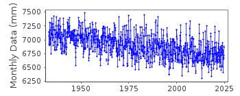
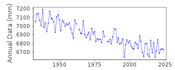
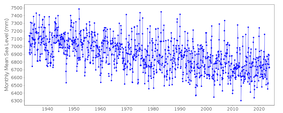
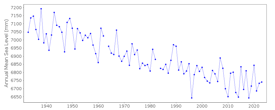
| Time span of data: | 1933 – 2024 |
| Completeness (%): | 99 |
| Date of last update: | 17 Feb 2025 |
| Green Arrow: | Current Station |
| Yellow Marker: | Neighbouring RLR Station |
| Red Marker: | Neighbouring Metric Station |
Please note: In many cases, the station position in our database is accurate to only one minute. Thus, the tide gauge may not appear to be on the coast.
Tide Gauge Data
Additional Data Sources (guide to additional data sources)
Nearby GNSS Stations from SONEL: OLK2, OLKIStation Documentation
Link to RLR information.Documentation added 1991-06-11
Rauma/Raumo 060/121 RLR(1964) is 7.7m below BMP3Documentation added 1993-07-12
Rauma/Raumo 060/121 RLR(1964) is 7.7m below BMP3Documentation added 2002-09-24
A description of the sea level network in Finland can be foundin 'Operational Oceanography: Implementation at the European
and Regional scales. 2002 (pp.129-137)'.
PRIOR TO 1971 FCODE=06
PRIOR TO 1983 GAUGE AT 61 08 N, 21 27 E
Documentation added 2012-01-09
The tide gauge at Rauma was moved during 1983. Levelling information recentlysupplied by the Finnish Meterological Institute confirms that benchmark P3 no
longer exists. Primary benchmark is now 92403 4.089m above the gauge datum.
Documentation added 2019-11-27
From 2018 onwards the averages of the Finnish sea level data will be based on 1 min observations. Values are calculated in Finnish normal time (EET).The data are relative to the reference surface of the Finnish sea level observations and thus the datum is the tide gauge zero.
Data Authority
Finnish Meteorological InstituteMarine Research, Waves and Sea Level
Erik Palenin aukio 1
P.O. Box 503
FI - 00101 Helsinki

![]()
![]()
![]()
