Data
- Obtaining
- Supplying
- High-Frequency
- Bottom Pressure Records
- Other Long Records
- GLOSS/ODINAFRICA Calibration Data
Donate
Donate to PSMSL
Data Notes
- Individual Station Data and Plot Notes
- Referencing the Data Set
- PSMSL Help File
- 2010 Changes to the PSMSL Data Files
Extracted from Database
20 Jul 2026
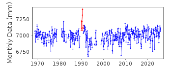
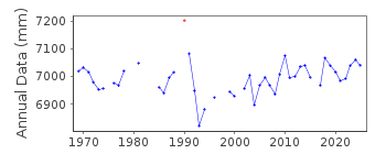
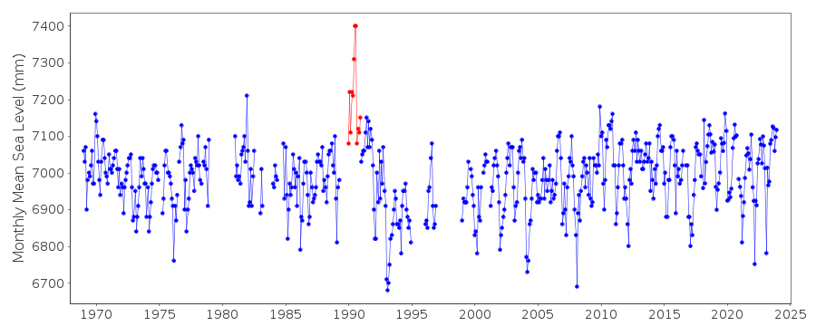
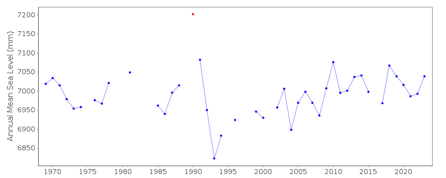
WARNING: QCFLAG EXISTS. PLEASE READ THE DOCUMENTATION.
Station Information
| Station ID: | 374 |
| Latitude: | 37.937328 |
| Longitude: | 23.626714 |
| Coastline code: | 290 |
| Station code: | 31 |
| Country: | GREECE |
| Time span of RLR data: | 1969 – 2025 |
| RLR completeness (%): | 85 |
| Time span of metric data: | 1933 – 2025 |
| Metric completeness (%): | 67 |
| Date of last update: | 13 Mar 2026 |
| Green Arrow: | Current Station |
| Yellow Marker: | Neighbouring RLR Station |
| Red Marker: | Neighbouring Metric Station |
Please note: In many cases, the station position in our database is accurate to only one minute. Thus, the tide gauge may not appear to be on the coast.
Tide Gauge Data
Additional Data Sources (guide to additional data sources)
Nearby Real Time Stations from VLIZ: peirStation Documentation
Link to RLR information.Documentation added 1991-06-11
Piraievs 290/031 RLR(1981) is 21.5m below BM R287Documentation added 1997-03-11
The contributing authority advises that anomalous values are the result of met. influences. Values for July - September 1990 affected by missing dataDocumentation added 2008-04-09
When the method of sea level measurement was changed from recording downwards to the more conventional upwards measurement the benchmark was changed from the previous R287 to the currently defined R10 7.130m R15 1.567m and R20 1.784m. PSMSL is currently in correspondence with HNHS to establish the relationship of these revised benchmarks with R287. We have been unable to establish a relationship between the benchmarks so the data remains 'Metric' from January 2003 and the station has been flagged. However the station retains its RLR status so that the 'good' RLR data is available on the database.Documentation added 2013-08-07
Following receipt of datum diagrams from the Hellenic Navy the RLR diagram has been re-drawn. In consequence both the RLR factors and the benchmark reference have changed.Data Authority
Hellenic Navy Hydrographic ServiceGeographic Policy and International Relations Office
TGN 1040
Athens

![]()
![]()
![]()
