Data
- Obtaining
- Supplying
- High-Frequency
- Bottom Pressure Records
- Other Long Records
- GLOSS/ODINAFRICA Calibration Data
Donate
Donate to PSMSL
Data Notes
- Individual Station Data and Plot Notes
- Referencing the Data Set
- PSMSL Help File
- 2010 Changes to the PSMSL Data Files
Extracted from Database
13 Jul 2026
Station Information
| Station ID: | 361 |
| Latitude: | 57.144056 |
| Longitude: | -2.077361 |
| Coastline code: | 170 |
| Station code: | 11 |
| Country: | UNITED KINGDOM |
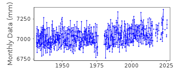
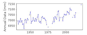
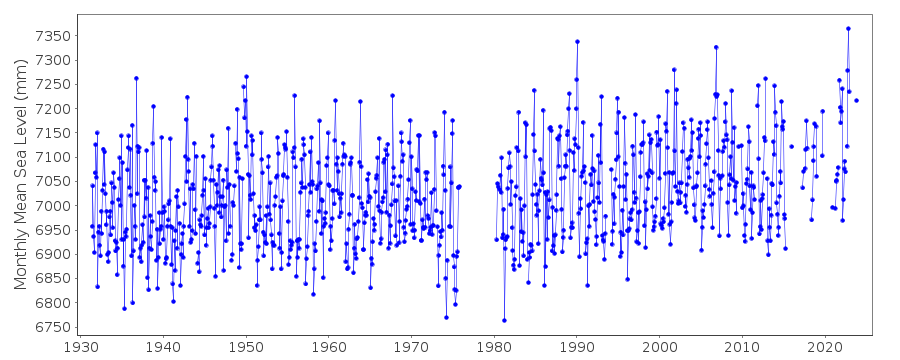
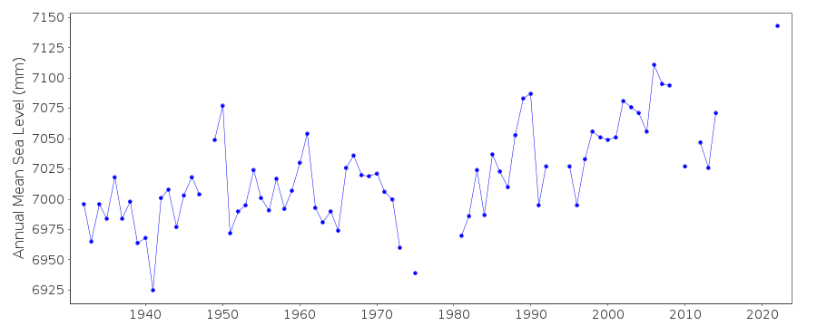
| Time span of data: | 1931 – 2025 |
| Completeness (%): | 85 |
| Link to ellipsoid: | Available |
| Date of last update: | 19 Feb 2026 |
| Green Arrow: | Current Station |
| Yellow Marker: | Neighbouring RLR Station |
| Red Marker: | Neighbouring Metric Station |
Please note: In many cases, the station position in our database is accurate to only one minute. Thus, the tide gauge may not appear to be on the coast.
Tide Gauge Data
Additional Data Sources (guide to additional data sources)
Nearby GNSS Stations from SONEL: ABERNearby Real Time Stations from VLIZ: abed
Station Documentation
Link to RLR information.Documentation added 1991-06-11
Aberdeen I 170/011 RLR(1964) is 10.4m below BM NJ9558 0581Documentation added 1994-07-20
Cary-Porter stilling well gauge installed May 1930, replaced with Munro July 1967, and moved to a new site February 1973. A Neyrpic temporary gauge was installed during harbour worksNovember 1975-December 1976. A new Munro was installed in December 1979, replaced by an "A Class" bubbler in December 1985.
Documentation added 1995-08-16
The two Aberdeen records are because one (170/011) is MSL and the other (170/012) is MTL (Mean Tide Level). There is a systematic 14 mm difference in datum between the two which can be determined from the period of overlap - see 'Trends in UK mean sea level' by P.L.Woodworth, Marine Geodesy, 11, 57-87, 1987.Documentation added 1996-11-25
Correspondence between MSL and MTL (series 170/011 and 170/012) is poor around 1948 because of many missing days.Documentation added 1997-07-17
September 1993: gauge removed February 1994: gauge re-installedDocumentation added 2001-01-02
Recent work on vertical land movements in the UK can be found from the University of Nottingham web site: http://ukcogr.iessg.nottingham.ac.uk/~eosi/Documentation added 2012-05-24
Previous Primary benchmark NJ 9558 0581 was destroyed before 1991. Current Primary benchmark is NJ 9525 0590 6.318m above TGZ.Documentation added 2014-07-02
Divers visited the site during Oct. 2012 to clean and clear blocked nozzle fittings. Subsequently the channels were reading ~40-60mm high.This was rectified by the channels being re-aligned in January 2013.Documentation added 2015-05-06
Reading were between 20-40mm low during January and approximately 30mm low during October. The compressor was changed on 9.10.2014. No levelling was carried out during 2014.Data Authority
Environment AgencyHorizon House
Deanery Road
BS1 5AH
Bristol

![]()
![]()
![]()
