Data
- Obtaining
- Supplying
- High-Frequency
- Bottom Pressure Records
- Other Long Records
- GLOSS/ODINAFRICA Calibration Data
Donate
Donate to PSMSL
Data Notes
- Individual Station Data and Plot Notes
- Referencing the Data Set
- PSMSL Help File
- 2010 Changes to the PSMSL Data Files
Extracted from Database
13 Jul 2026
Station Information
| Station ID: | 34 |
| Latitude: | 63.433333 |
| Longitude: | 10.433333 |
| Coastline code: | 40 |
| Station code: | 141 |
| Country: | NORWAY |
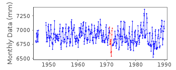
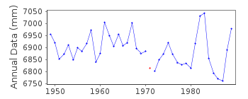
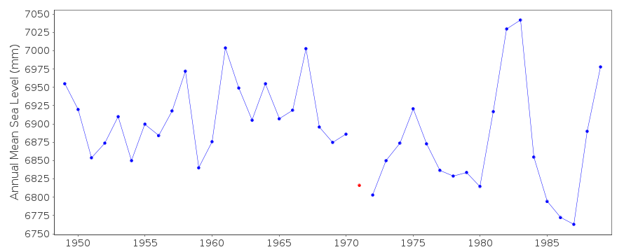
| Time span of RLR data: | 1945 – 1989 |
| RLR completeness (%): | 93 |
| Time span of metric data: | 1872 – 1989 |
| Metric completeness (%): | 40 |
| Date of last update: | 30 Sep 1991 |
| Green Arrow: | Current Station |
| Yellow Marker: | Neighbouring RLR Station |
| Red Marker: | Neighbouring Metric Station |
Please note: In many cases, the station position in our database is accurate to only one minute. Thus, the tide gauge may not appear to be on the coast.
Tide Gauge Data
Additional Data Sources (guide to additional data sources)
Nearby GNSS Stations from SONEL: TRDSNearby Real Time Stations from VLIZ: tron
Station Documentation
Link to RLR information.Documentation added 1991-06-11
Trondheim 040/141 RLR(1964) is 10.4m below BM"Sodemannsgt"Documentation added 1993-07-12
Trondheim 040/141 RLR(1964) is 10.4m below BM"Sodemannsgt"Documentation added 1994-07-11
Anomalously low values July-September 1971 correct as receivedfrom authority.
Documentation added 1994-10-10
new gauge established in December 1989 but treated as separatestation (040/142) as no connection between old and new bench marks
Documentation added 1995-03-30
prior to 1978 fcode=hlDocumentation added 1995-03-30
tide gauge network modernised, new equipment installed in 1989Trondheim is an historic station last data 1989
Data Authority
Norwegian Mapping AuthorityHydrographic Service
Po. Box 60
4001 Stavanger

![]()
![]()
![]()
