Data
- Obtaining
- Supplying
- High-Frequency
- Bottom Pressure Records
- Other Long Records
- GLOSS/ODINAFRICA Calibration Data
Donate
Donate to PSMSL
Data Notes
- Individual Station Data and Plot Notes
- Referencing the Data Set
- PSMSL Help File
- 2010 Changes to the PSMSL Data Files
Extracted from Database
20 Jul 2026
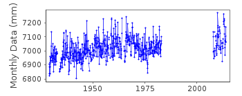
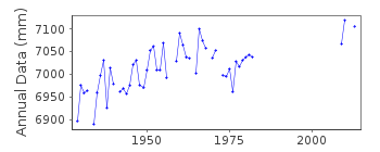
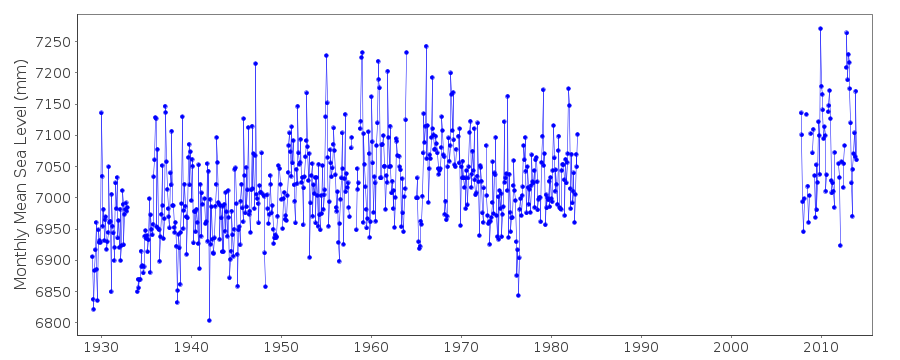
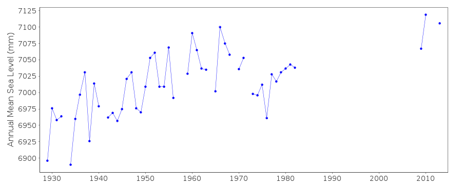
Station Information
| Station ID: | 336 |
| Latitude: | 51.5 |
| Longitude: | 0.083333 |
| Coastline code: | 170 |
| Station code: | 92 |
| Country: | UNITED KINGDOM |
| Time span of data: | 1929 – 2013 |
| Completeness (%): | 65 |
| Date of last update: | 17 Jan 2018 |
| Green Arrow: | Current Station |
| Yellow Marker: | Neighbouring RLR Station |
| Red Marker: | Neighbouring Metric Station |
Please note: In many cases, the station position in our database is accurate to only one minute. Thus, the tide gauge may not appear to be on the coast.
Tide Gauge Data
Station Documentation
Link to RLR information.Documentation added 1994-09-20
Cary-Porter/stilling well Jan 1930-February 1951 Kent/stilling well February 1951 onwardsDocumentation added 2001-01-02
Recent work on vertical land movements in the UK can be found from the University of Nottingham web site: http://ukcogr.iessg.nottingham.ac.uk/~eosi/Documentation added 2016-10-11
To adjust the data for 1929-1973 from ODN to Chart Datum 3.200m has been added to the data.Data Authority
Port of London AuthorityLondon River House
Royal Pier Road
Gravesend
Kent DA12 2BG

![]()
![]()
![]()
