Data
- Obtaining
- Supplying
- High-Frequency
- Bottom Pressure Records
- Other Long Records
- GLOSS/ODINAFRICA Calibration Data
Donate
Donate to PSMSL
Data Notes
- Individual Station Data and Plot Notes
- Referencing the Data Set
- PSMSL Help File
- 2010 Changes to the PSMSL Data Files
Extracted from Database
13 Jul 2026
Station Information
| Station ID: | 334 |
| Latitude: | 51.51445 |
| Longitude: | 0.72378 |
| Coastline code: | 170 |
| Station code: | 81 |
| Country: | UNITED KINGDOM |
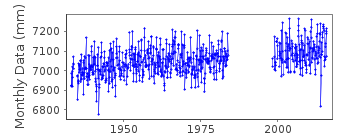
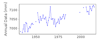
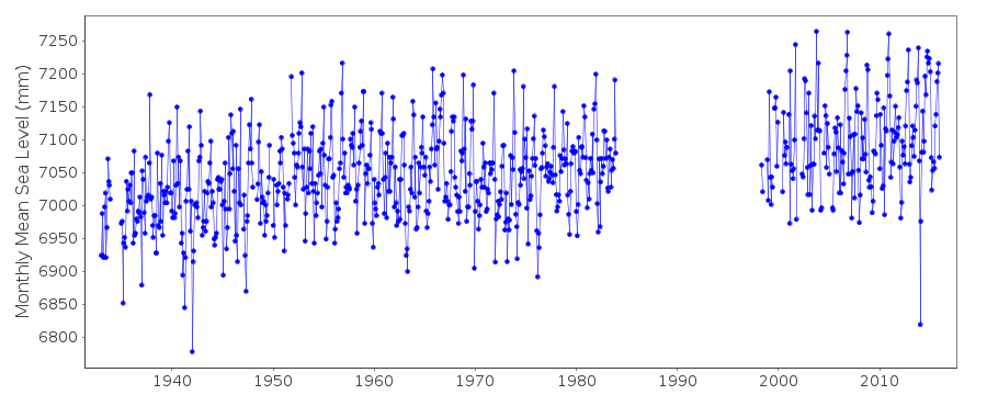
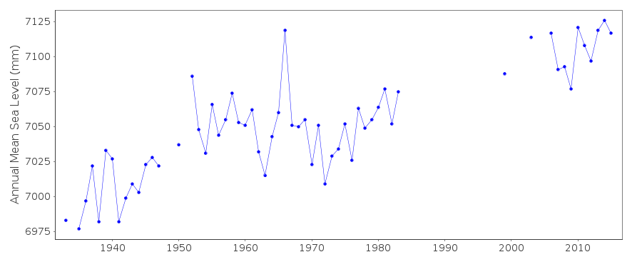
| Time span of RLR data: | 1933 – 2015 |
| RLR completeness (%): | 78 |
| Time span of metric data: | 1929 – 2015 |
| Metric completeness (%): | 79 |
| Date of last update: | 17 May 2016 |
| Green Arrow: | Current Station |
| Yellow Marker: | Neighbouring RLR Station |
| Red Marker: | Neighbouring Metric Station |
Please note: In many cases, the station position in our database is accurate to only one minute. Thus, the tide gauge may not appear to be on the coast.
Tide Gauge Data
Additional Data Sources (guide to additional data sources)
Nearby GNSS Stations from SONEL: SHOENearby Real Time Stations from VLIZ: shee2, shee
Station Documentation
Link to RLR information.Documentation added 1991-06-11
Southend 170/081 RLR(1964) is 12.1m below TGBM TQ8898 8303Documentation added 1993-07-12
Southend 170/081 RLR(1964) is 12.1m below TGBM TQ8898 8303Documentation added 1994-09-20
Stilling well gauges as follows; Jan 1929 - December 1944, Cary-Porter Jan 1945 - April 1950, Hughes (probably)May 1950 - KentDocumentation added 2001-01-02
Recent work on vertical land movements in the UK can be found from the University of Nottingham web site: http://ukcogr.iessg.nottingham.ac.uk/~eosi/Documentation added 2016-05-17
Southend data for 1998-2015 has been supplied by the Port of London Authority (PLA). Previous data ended in 1983 the PLA has confirmed that the datum for the data 1998-2015 remains the same. The values of latitude and longitude were also updated.Data Authority
Port of London AuthorityLondon River House
Royal Pier Road
Gravesend
Kent DA12 2BG

![]()
![]()
![]()
