Data
- Obtaining
- Supplying
- High-Frequency
- Bottom Pressure Records
- Other Long Records
- GLOSS/ODINAFRICA Calibration Data
Donate
Donate to PSMSL
Data Notes
- Individual Station Data and Plot Notes
- Referencing the Data Set
- PSMSL Help File
- 2010 Changes to the PSMSL Data Files
Extracted from Database
13 Jul 2026
Station Information
| Station ID: | 321 |
| Latitude: | 59.45 |
| Longitude: | 24.8 |
| Coastline code: | 82 |
| Station code: | 11 |
| Country: | ESTONIA |
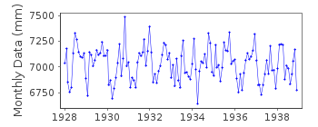
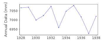
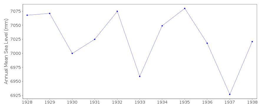
| Time span of data: | 1928 – 1938 |
| Completeness (%): | 100 |
| Date of last update: | 01 Jan 1980 |
| Green Arrow: | Current Station |
| Yellow Marker: | Neighbouring RLR Station |
| Red Marker: | Neighbouring Metric Station |
Please note: In many cases, the station position in our database is accurate to only one minute. Thus, the tide gauge may not appear to be on the coast.
Tide Gauge Data
Additional Data Sources (guide to additional data sources)
Nearby GNSS Stations from SONEL: MUST, SUR4, MUS2, SUURStation Documentation
Link to RLR information.Documentation added 1991-06-11
Tallinn 080/011 RLR(1938) is 8.7m below BM Custom HouseDocumentation added 1993-07-12
Tallinn 080/011 RLR(1938) is 8.7m below BM Custom HouseDocumentation added 1994-07-11
This station is in Estonia.Tallinn is an historic station last data 1938
Data Authority
World Data CenterRussian Federal Service for Hydrometeorology
and Environmental Monitoring
6 Korolev Street, 249035 Obninsk
Kaluga Region

![]()
![]()
![]()
