Data
- Obtaining
- Supplying
- High-Frequency
- Bottom Pressure Records
- Other Long Records
- GLOSS/ODINAFRICA Calibration Data
Donate
Donate to PSMSL
Data Notes
- Individual Station Data and Plot Notes
- Referencing the Data Set
- PSMSL Help File
- 2010 Changes to the PSMSL Data Files
Extracted from Database
13 Jul 2026
WARNING: QCFLAG EXISTS. PLEASE READ THE DOCUMENTATION.
Station Information
| Station ID: | 303 |
| Latitude: | 28.477182 |
| Longitude: | -16.241156 |
| Coastline code: | 370 |
| Station code: | 21 |
| Country: | SPAIN |
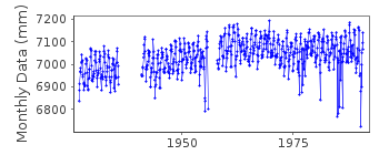
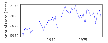
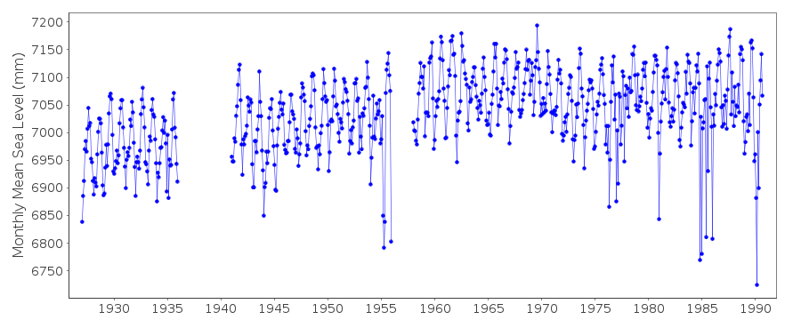
| Time span of data: | 1927 – 1990 |
| Completeness (%): | 89 |
| Link to ellipsoid: | Available |
| Date of last update: | 13 Aug 2024 |
| Green Arrow: | Current Station |
| Yellow Marker: | Neighbouring RLR Station |
| Red Marker: | Neighbouring Metric Station |
Please note: In many cases, the station position in our database is accurate to only one minute. Thus, the tide gauge may not appear to be on the coast.
Tide Gauge Data
Additional Data Sources (guide to additional data sources)
Nearby GNSS Stations from SONEL: GRAF, LLAG, TN01Nearby Real Time Stations from VLIZ: tene
Research Quality Data from UHSLC station 228: hourly and daily
Station Documentation
Link to RLR information.Documentation added 1991-06-11
S Cruz de TenerifeI 370/021 RLR(1964) is 12.2m below NAP-380Documentation added 1993-07-12
Many anomalously low monthly values in the mid-1950s and the mid- and late-1980s.Documentation added 1993-12-14
Gauge out of order since 1990. This is an historic station last data 1990Data Authority
Instituto Geográfico NacionalRed de Infraestructuras Geodésicas
General Ibáñez de Ibero, 3
28003, Madrid

![]()
![]()
![]()
