Data
- Obtaining
- Supplying
- High-Frequency
- Bottom Pressure Records
- Other Long Records
- GLOSS/ODINAFRICA Calibration Data
Donate
Donate to PSMSL
Data Notes
- Individual Station Data and Plot Notes
- Referencing the Data Set
- PSMSL Help File
- 2010 Changes to the PSMSL Data Files
Extracted from Database
13 Jul 2026
Station Information
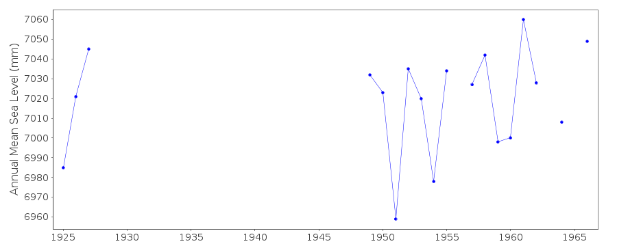
| Station ID: | 271 |
| Latitude: | 54.933333 |
| Longitude: | 10.066667 |
| Coastline code: | 130 |
| Station code: | 61 |
| Country: | DENMARK |
| Time span of RLR data: | 1925 – 1967 |
| RLR completeness (%): | 46 |
| Time span of metric data: | 1925 – 1967 |
| Metric completeness (%): | 48 |
| Date of last update: | 01 Jan 1980 |
| Green Arrow: | Current Station |
| Yellow Marker: | Neighbouring RLR Station |
| Red Marker: | Neighbouring Metric Station |
Please note: In many cases, the station position in our database is accurate to only one minute. Thus, the tide gauge may not appear to be on the coast.
Tide Gauge Data

Additional Data Sources (guide to additional data sources)
Nearby Real Time Stations from VLIZ: fynsStation Documentation
Link to RLR information.Documentation added 1991-06-11
Mommark 130/061 RLR(1964) is 22.7m below BMVDocumentation added 1992-01-29
Recording stopped in 1966, gauge moved to FynshavDocumentation added 1993-07-12
Mommark 130/061 RLR(1964) is 22.7m below BM GI 1629Documentation added 2012-10-03
Mommark is an historic station. Last data 1967Data Authority
Det Danske Meteorologiske InstitutObservation Department, Operations Division
Lyngbyvej 100
DK-2100 Kobenhavn

![]()
![]()
![]()
