Data
- Obtaining
- Supplying
- High-Frequency
- Bottom Pressure Records
- Other Long Records
- GLOSS/ODINAFRICA Calibration Data
Donate
Donate to PSMSL
Data Notes
- Individual Station Data and Plot Notes
- Referencing the Data Set
- PSMSL Help File
- 2010 Changes to the PSMSL Data Files
Extracted from Database
13 Jul 2026
WARNING: QCFLAG EXISTS. PLEASE READ THE DOCUMENTATION.
Station Information
| Station ID: | 255 |
| Latitude: | 51.114389 |
| Longitude: | 1.322667 |
| Coastline code: | 170 |
| Station code: | 111 |
| Country: | UNITED KINGDOM |
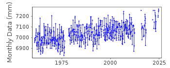
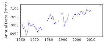
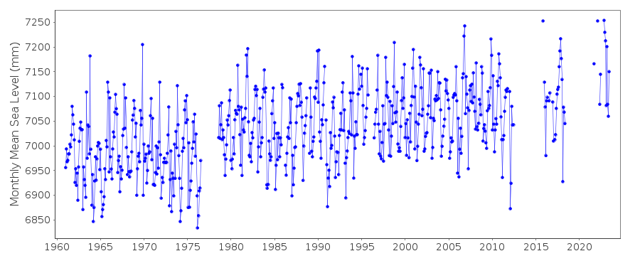
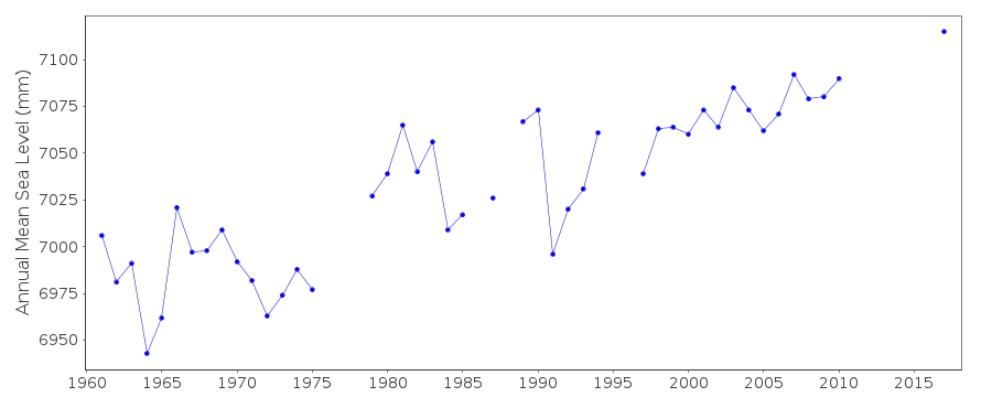
| Time span of RLR data: | 1961 – 2024 |
| RLR completeness (%): | 81 |
| Time span of metric data: | 1924 – 2024 |
| Metric completeness (%): | 78 |
| Link to ellipsoid: | Available |
| Date of last update: | 19 Feb 2026 |
| Green Arrow: | Current Station |
| Yellow Marker: | Neighbouring RLR Station |
| Red Marker: | Neighbouring Metric Station |
Please note: In many cases, the station position in our database is accurate to only one minute. Thus, the tide gauge may not appear to be on the coast.
Tide Gauge Data
Additional Data Sources (guide to additional data sources)
Nearby GNSS Stations from SONEL: DVTGNearby Real Time Stations from VLIZ: dove
Station Documentation
Link to RLR information.Documentation added 1991-06-11
Dover 170/111 RLR(1984) is 13.8m below TGBMTR3193 4074Documentation added 1993-03-17
Possible datum shift in RLR record after data gap in the late 1970's.Documentation added 1993-10-11
1960 values are based on 8 readings a dayDocumentation added 1994-07-20
Gauge was originally a Cary-Porter stilling well gauge, replaced by a Lege in July 1959, a Lea in October 1965, a Neyrpic in July 1976, and a Munro/Ott combination in 1978. From March 1986 data have been from a POL-designed potentiometer attached to the stilling well.Documentation added 1994-09-20
March-December 1959: records unreliable 1976: harbour modificationsDocumentation added 1997-07-16
Data revised on receipt of additional TGBM informationDocumentation added 2001-01-02
Recent work on vertical land movements in the UK can be found from the University of Nottingham web site: http://ukcogr.iessg.nottingham.ac.uk/~eosi/Documentation added 2014-07-02
No data available for Dover 2013 as the primary channel recording ~100m high in places and has been flagged.Documentation added 2015-05-06
There is no data available for 2014 for Dover readings were erratic with the primary channel being up to 100mm high due to blocking.Data Authority
Environment AgencyHorizon House
Deanery Road
BS1 5AH
Bristol

![]()
![]()
![]()
