Data
- Obtaining
- Supplying
- High-Frequency
- Bottom Pressure Records
- Other Long Records
- GLOSS/ODINAFRICA Calibration Data
Donate
Donate to PSMSL
Data Notes
- Individual Station Data and Plot Notes
- Referencing the Data Set
- PSMSL Help File
- 2010 Changes to the PSMSL Data Files
Extracted from Database
13 Jul 2026
WARNING: QCFLAG EXISTS. PLEASE READ THE DOCUMENTATION.
Station Information
| Station ID: | 253 |
| Latitude: | 31.25 |
| Longitude: | 32.3 |
| Coastline code: | 330 |
| Station code: | 1 |
| Country: | EGYPT |
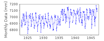
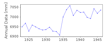
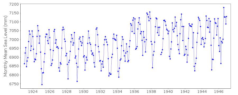
| Time span of data: | 1923 – 1946 |
| Completeness (%): | 100 |
| Date of last update: | 01 Jan 1980 |
| Green Arrow: | Current Station |
| Yellow Marker: | Neighbouring RLR Station |
| Red Marker: | Neighbouring Metric Station |
Please note: In many cases, the station position in our database is accurate to only one minute. Thus, the tide gauge may not appear to be on the coast.
Tide Gauge Data
Station Documentation
Link to RLR information.Documentation added 1991-06-11
Port Said 330/001 RLR(1946) is 8.3m below BMDocumentation added 1993-03-17
Apparent datum shift in RLR record around 1936.Documentation added 1994-07-14
For a discussion of submergence near to Port Said see Emery and Aubrey (Sea Levels, Land Levels and Tide Gauges), 1991, Springer-Verlag, page 35. However, see also note above about possible datum shift in the tide gauge data.Documentation added 1997-10-01
Analysis of Suez Canal data is described by F.M.Eid, S.H.Sharaf El-Din and K.A.Alam El-Din, "Sea-level variation along the Suez Canal",Estuarine, Coastal and Shelf Science,44,613-619,1997.Data Authority
Egyptian National Oceanographic Data CentreInstitute of Oceanography and Fisheries
Kayet Bay
Alexandria

![]()
![]()
![]()
