Data
- Obtaining
- Supplying
- High-Frequency
- Bottom Pressure Records
- Other Long Records
- GLOSS/ODINAFRICA Calibration Data
Donate
Donate to PSMSL
Data Notes
- Individual Station Data and Plot Notes
- Referencing the Data Set
- PSMSL Help File
- 2010 Changes to the PSMSL Data Files
Extracted from Database
13 Jul 2026
Station Information
| Station ID: | 247 |
| Latitude: | -43.60563 |
| Longitude: | 172.72194 |
| Coastline code: | 690 |
| Station code: | 21 |
| Country: | NEW ZEALAND |
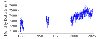
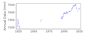
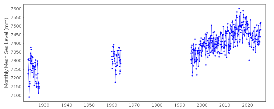
| Time span of data: | 1923 – 2025 |
| Completeness (%): | 37 |
| Date of last update: | 17 Feb 2026 |
| Green Arrow: | Current Station |
| Yellow Marker: | Neighbouring RLR Station |
| Red Marker: | Neighbouring Metric Station |
Please note: In many cases, the station position in our database is accurate to only one minute. Thus, the tide gauge may not appear to be on the coast.
Tide Gauge Data
Additional Data Sources (guide to additional data sources)
Nearby GNSS Stations from SONEL: LYTT, MQZGResearch Quality Data from UHSLC station 667: hourly and daily
Station Documentation
Link to RLR information.Documentation added 1991-06-11
Port Lyttelton 690/021 RLR(1963) is 10.1m below BM UD40Documentation added 1995-04-28
1961-62 revised, 28th April 1995Documentation added 2003-01-17
New data from John Hannah added 17/01/03 which supercedes old data. New data does not have any missing days information. Old data has been backed up.Documentation added 2003-01-17
New data from John Hannah was for Auckland II, Dunedin II, Lyttelton II and Wellington II.Documentation added 2005-10-17
There is a new John Hannah paper referring to New Zealand data for Wellington, Dunedin, Lyttelton and Auckland. The reference is: "An updated analysis of long-term sea level change in New Zealand." Geophysical Research Letters, V31, L03307, doi:10.1029/2003GL019166 (2004).Documentation added 2008-10-07
Data received from Glen Rowe of LINZ for 1995-2007 Previous data held ends in 1964. Bench mark details were clarified. Bench mark at Port Lyttelton remains BM UD 40 - see email of 7.10.08.Documentation added 2014-09-02
There is currently no data for Lyttelton for 2013 while LINZ investigate possible problems with the tide gauge.Documentation added 2015-08-19
With the supply of the 2014 sea level data Glen Rowe from LINZ also send revised data values Port Lyttelton for 2010-2013 to ensure that the post earthquake values have been corrected to the historic zero datum.Documentation added 2018-06-28
The Kaikoura earthquake of 13 November 2016 at 23:02 impacted a number of stations in the central part of New Zealand. For this reason hourly values from 14th November 00:00hrs have been adjusted by LINZ. The adjustment at Lyttelton is -0.030mDocumentation added 2020-08-25
The adjustment due to the Kaikōura earthquake of 2016 has been removed as relative sea level series should include land movement.Documentation added 2021-08-23
A revised copy of the New Zealand data values for Port Lyttelton has been received from the data supplier the Land Information New Zealand (LINZ). The revised data begins from 2014. This exercise has been carried out to correct some anomalies with the high frequency data.Adjustment has also been applied to the data to account for the Kaikoura earthquake by creating a new datum TGZ December 2016 4.371m below benchmark UD40.
Consequently the Metric data has had the effect of Kaikoura removed but the effect of the earthquake is evident in the RLR data.
Documentation added 2024-10-23
LINZ have informed us that the station was relocated on 4 September 2020, and since then the tide gauge zero has been Chart Datum, 4.478 m below UD40. RLR data from September 2020 onward has been recomputed.Data Authority
Land Information New Zealand155 The Terrace
PO 5501
Wellington 6145

![]()
![]()
![]()
