Data
- Obtaining
- Supplying
- High-Frequency
- Bottom Pressure Records
- Other Long Records
- GLOSS/ODINAFRICA Calibration Data
Donate
Donate to PSMSL
Data Notes
- Individual Station Data and Plot Notes
- Referencing the Data Set
- PSMSL Help File
- 2010 Changes to the PSMSL Data Files
Extracted from Database
13 Jul 2026
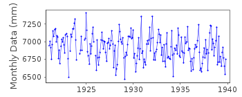
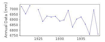
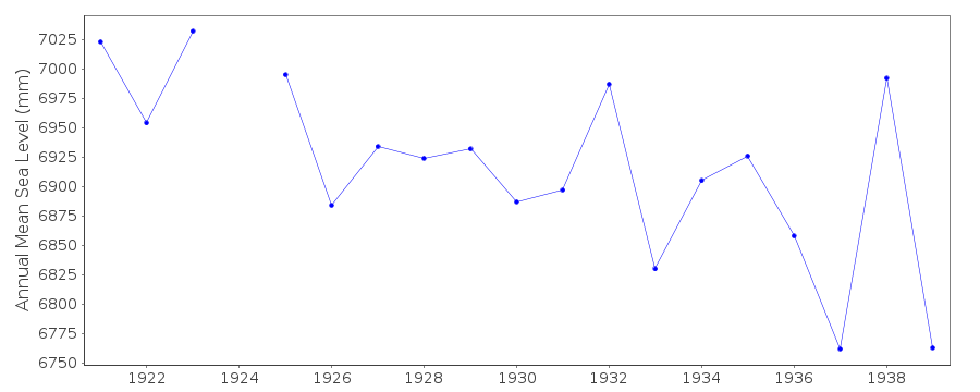
Station Information
| Station ID: | 237 |
| Latitude: | 60.35 |
| Longitude: | 28.616667 |
| Coastline code: | 80 |
| Station code: | 4 |
| Country: | RUSSIAN FEDERATION |
| Time span of data: | 1921 – 1939 |
| Completeness (%): | 96 |
| Date of last update: | 01 Jan 1980 |
| Green Arrow: | Current Station |
| Yellow Marker: | Neighbouring RLR Station |
| Red Marker: | Neighbouring Metric Station |
Please note: In many cases, the station position in our database is accurate to only one minute. Thus, the tide gauge may not appear to be on the coast.
Tide Gauge Data
Station Documentation
Link to RLR information.Documentation - date unknown
1921 - 1925 VALUES BASED ON 3 READINGS PER DAYStation is in Russia. Formerly Finland and known as Koivisto
Documentation added 1991-06-11
Primorsk 080/004 RLR(1938) is 10.1m below BM 2215XDocumentation added 1993-07-12
Primorsk 080/004 RLR(1938) is 10.1m below BM 2215XPrimorsk is an historic station last data 1939
Data Authority
Finnish Meteorological InstituteMarine Research, Waves and Sea Level
Erik Palenin aukio 1
P.O. Box 503
FI - 00101 Helsinki

![]()
![]()
![]()
