Data
- Obtaining
- Supplying
- High-Frequency
- Bottom Pressure Records
- Other Long Records
- GLOSS/ODINAFRICA Calibration Data
Donate
Donate to PSMSL
Data Notes
- Individual Station Data and Plot Notes
- Referencing the Data Set
- PSMSL Help File
- 2010 Changes to the PSMSL Data Files
Extracted from Database
13 Jul 2026
Station Information
| Station ID: | 234 |
| Latitude: | 32.781667 |
| Longitude: | -79.925 |
| Coastline code: | 960 |
| Station code: | 41 |
| Country: | UNITED STATES |
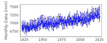
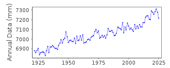
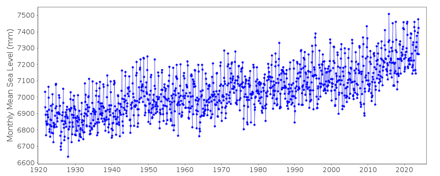
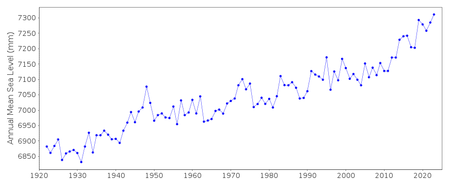
| Time span of data: | 1921 – 2025 |
| Completeness (%): | 99 |
| Date of last update: | 27 Jan 2026 |
| Green Arrow: | Current Station |
| Yellow Marker: | Neighbouring RLR Station |
| Red Marker: | Neighbouring Metric Station |
Please note: In many cases, the station position in our database is accurate to only one minute. Thus, the tide gauge may not appear to be on the coast.
Tide Gauge Data
Additional Data Sources (guide to additional data sources)
Nearby GNSS Stations from SONEL: SCCC, SCHA, CHA1Fast Delivery Data from UHSLC station 261: hourly and daily
Research Quality Data from UHSLC station 261: hourly and daily
Station Documentation
Link to RLR information.Documentation added 1991-06-11
Charleston I 960/041 RLR(1964) is 9.7m below BM1Documentation added 2011-07-27
Data downloaded directly from the NOAA database. Datum information also downloaded. NOAA Primary Benchmark is NO 13 1928 ELEV 8.264FT 4.02m above TGZ. Previous benchmark used BM1 4.334m above gauge zero. This corresponde with benchmark PORT 1962 values 4.333m above gauge datum for Epoch 1960-1978. 4.334m above for Epoch 1983-2001.Data Authority
N.O.A.A. / N.O.S.N/oes33, Ssmc4, Room 6531
1305 East-West Highway
Silver Spring,
MD 20910

![]()
![]()
![]()
