Data
- Obtaining
- Supplying
- High-Frequency
- Bottom Pressure Records
- Other Long Records
- GLOSS/ODINAFRICA Calibration Data
Donate
Donate to PSMSL
Data Notes
- Individual Station Data and Plot Notes
- Referencing the Data Set
- PSMSL Help File
- 2010 Changes to the PSMSL Data Files
Extracted from Database
13 Jul 2026
Station Information
| Station ID: | 2273 |
| Latitude: | 20.78 |
| Longitude: | -156.9 |
| Coastline code: | 760 |
| Station code: | 43 |
| Country: | UNITED STATES |
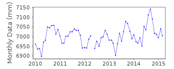
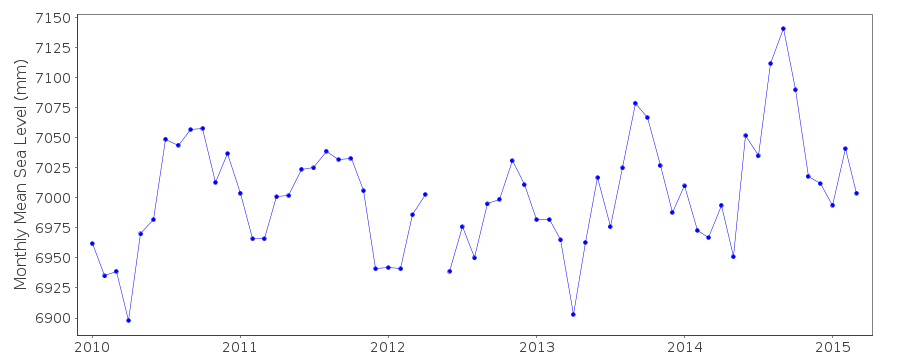
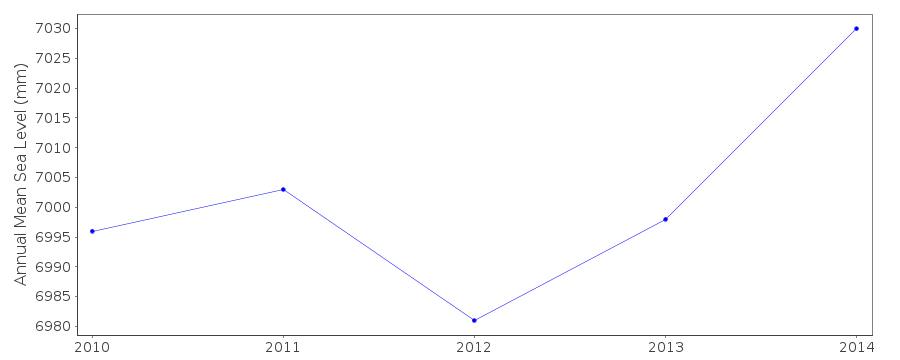
| Time span of RLR data: | 2010 – 2015 |
| RLR completeness (%): | 86 |
| Time span of metric data: | 2007 – 2015 |
| Metric completeness (%): | 85 |
| Date of last update: | 28 Feb 2018 |
| Green Arrow: | Current Station |
| Yellow Marker: | Neighbouring RLR Station |
| Red Marker: | Neighbouring Metric Station |
Please note: In many cases, the station position in our database is accurate to only one minute. Thus, the tide gauge may not appear to be on the coast.
Tide Gauge Data

Additional Data Sources (guide to additional data sources)
Nearby Real Time Stations from VLIZ: maneFast Delivery Data from UHSLC station 429: hourly and daily
Station Documentation
Link to RLR information.Documentation added 2016-01-05
Lanai Island, Kaumalapau is a new UH station using information from UH levelling carried out in 2010 and 2012 the station has been made RLR. Primary benchmark is UH 1 3.089m above the datum.Data Authority
University of Hawaii Sea Level CenterDepartment of Oceanography Division of Natural Sciences
1000 Pope Road
Honolulu
Hawaii 96822

![]()
![]()
![]()
