Data
- Obtaining
- Supplying
- High-Frequency
- Bottom Pressure Records
- Other Long Records
- GLOSS/ODINAFRICA Calibration Data
Donate
Donate to PSMSL
Data Notes
- Individual Station Data and Plot Notes
- Referencing the Data Set
- PSMSL Help File
- 2010 Changes to the PSMSL Data Files
Extracted from Database
13 Jul 2026
Station Information
| Station ID: | 219 |
| Latitude: | 54.6 |
| Longitude: | -5.916667 |
| Coastline code: | 170 |
| Station code: | 272 |
| Country: | UNITED KINGDOM |
| Time span of data: | 1917 – 1963 |
| Completeness (%): | 99 |
| Date of last update: | 31 May 1989 |
| Green Arrow: | Current Station |
| Yellow Marker: | Neighbouring RLR Station |
| Red Marker: | Neighbouring Metric Station |
Please note: In many cases, the station position in our database is accurate to only one minute. Thus, the tide gauge may not appear to be on the coast.
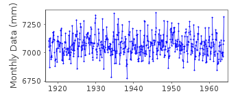
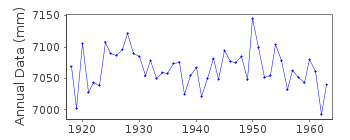
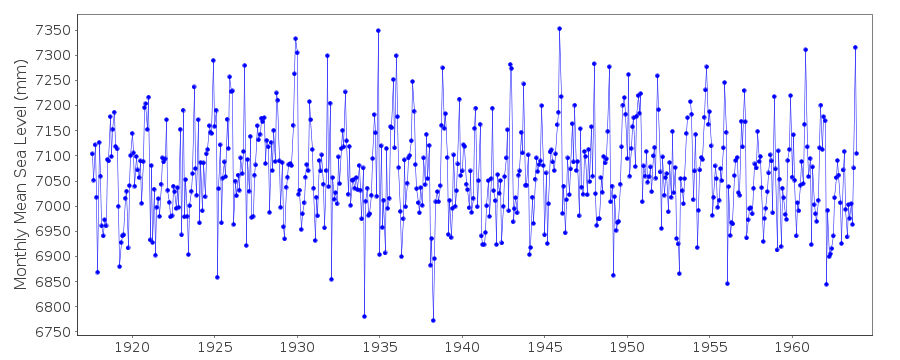
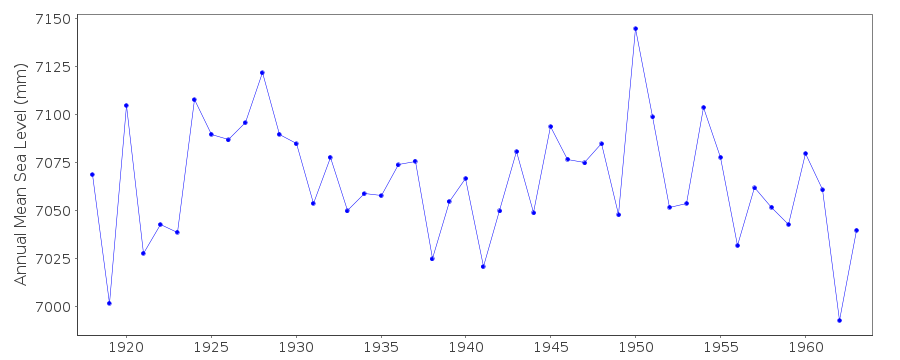
Tide Gauge Data
Additional Data Sources (guide to additional data sources)
Nearby GNSS Stations from SONEL: BFST, BELFStation Documentation
Link to RLR information.Documentation added 1991-06-11
Belfast 2 170/272 RLR(1963) is 10.0m below BM(33435W, 37496N)Documentation added 2001-01-02
Recent work on vertical land movements in the UK can be found fromthe University of Nottingham web site:
http://ukcogr.iessg.nottingham.ac.uk/~eosi/
BELFAST 2 HIGH AND LOW WATER DATA FROM BELFAST HARBOUR BOARD
VIA DR.BILL CARTER, UNIV.OF ULSTER.
LOCAL GROUND CONDITIONS UNSTABLE
Data Authority
British Oceanographic Data CentreNational Oceanography Centre
Joseph Proudman Building, 6 Brownlow Street
Liverpool
L3 5DA

![]()
![]()
![]()
