Data
- Obtaining
- Supplying
- High-Frequency
- Bottom Pressure Records
- Other Long Records
- GLOSS/ODINAFRICA Calibration Data
Donate
Donate to PSMSL
Data Notes
- Individual Station Data and Plot Notes
- Referencing the Data Set
- PSMSL Help File
- 2010 Changes to the PSMSL Data Files
Extracted from Database
20 Jul 2026
Station Information
| Station ID: | 215 |
| Latitude: | 44.1 |
| Longitude: | 39.066667 |
| GLOSS ID: | 98 |
| Coastline code: | 300 |
| Station code: | 1 |
| Country: | RUSSIAN FEDERATION |
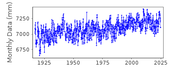
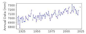
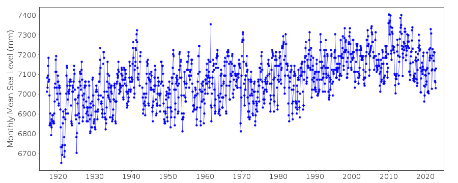
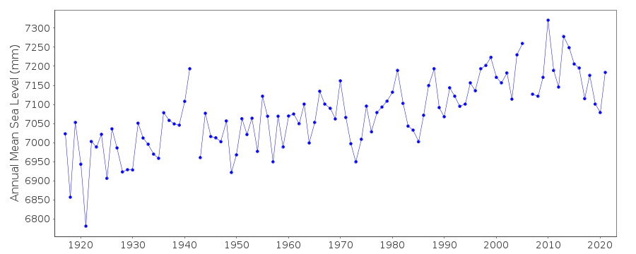
| Time span of data: | 1917 – 2024 |
| Completeness (%): | 99 |
| Date of last update: | 20 Oct 2025 |
| Green Arrow: | Current Station |
| Yellow Marker: | Neighbouring RLR Station |
| Red Marker: | Neighbouring Metric Station |
Please note: In many cases, the station position in our database is accurate to only one minute. Thus, the tide gauge may not appear to be on the coast.
Tide Gauge Data
Station Documentation
Link to RLR information.Documentation added 1994-07-14
Port Tuapse 300/011 RLR(1964) is 10.4m below BM 3816Documentation added 1999-03-10
For a discussion on sea level trends along Black Sea coasts see Variations of the Black Sea Level by S.G.Boguslavsky et al., Physical Oceanography, 9(3), 199-208, 1998.Documentation added 1999-03-10
See also comments under Bourgas (code 295/021).Documentation added 2016-01-26
Revised data values for 2013/2014 for Tuapse have been received from the World Data Centre. Previously the dataset for 2013 was for Jan-May only. The complete year for 2013 has now been supplied. The 2014 data for Tuapse was the complete year the recently supplied data has revised data values for several months and there is now no data for December 2014.Documentation added 2016-08-30
Some data values for 2011-2014 had been incorrectly changed. The original values have been restored.Data Authority
World Data CenterRussian Federal Service for Hydrometeorology
and Environmental Monitoring
6 Korolev Street, 249035 Obninsk
Kaluga Region

![]()
![]()
![]()
