Data
- Obtaining
- Supplying
- High-Frequency
- Bottom Pressure Records
- Other Long Records
- GLOSS/ODINAFRICA Calibration Data
Donate
Donate to PSMSL
Data Notes
- Individual Station Data and Plot Notes
- Referencing the Data Set
- PSMSL Help File
- 2010 Changes to the PSMSL Data Files
Extracted from Database
13 Jul 2026
WARNING: QCFLAG EXISTS. PLEASE READ THE DOCUMENTATION.
Station Information
| Station ID: | 214 |
| Latitude: | 51.957694 |
| Longitude: | 1.346556 |
| Coastline code: | 170 |
| Station code: | 71 |
| Country: | UNITED KINGDOM |
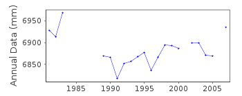
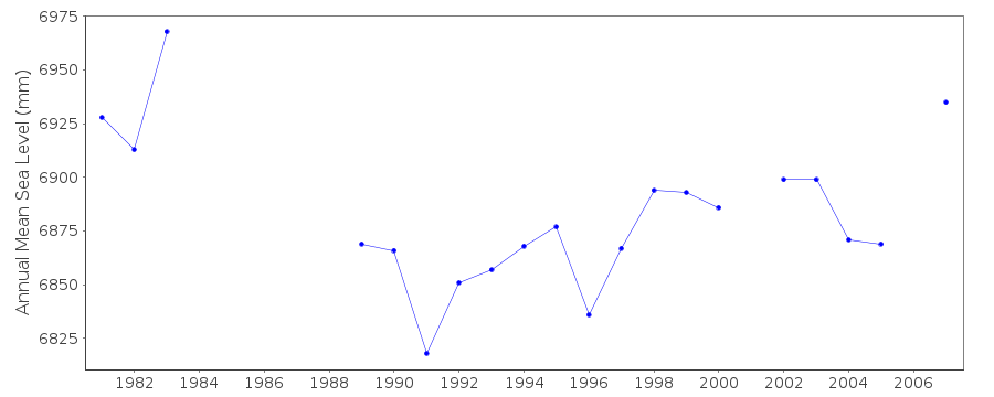
| Time span of RLR data: | 1980 – 2011 |
| RLR completeness (%): | 82 |
| Time span of metric data: | 1917 – 2011 |
| Metric completeness (%): | 61 |
| Date of last update: | 19 Feb 2026 |
| Green Arrow: | Current Station |
| Yellow Marker: | Neighbouring RLR Station |
| Red Marker: | Neighbouring Metric Station |
Please note: In many cases, the station position in our database is accurate to only one minute. Thus, the tide gauge may not appear to be on the coast.
Tide Gauge Data
Additional Data Sources (guide to additional data sources)
Nearby Real Time Stations from VLIZ: harwStation Documentation
Link to RLR information.Documentation added 1991-06-11
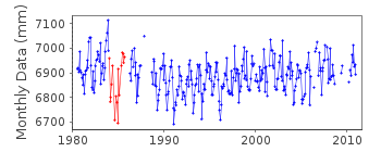
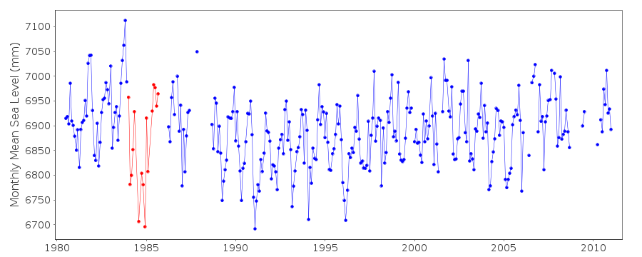
Felixstowe 170/071 RLR(1983) is 10.5m below TGBM TM3001 3414Documentation added 1992-04-01
1984-85 Aanderaa gauge - datum queriesDocumentation added 1994-07-21
A stilling well gauge, probably a Kelvin-Hughes type, was installed in July 1917 at the "tide gauge pier", replaced in November 1939 by another, probably also a Kelvin-Hughes, at the "Ordnance Pier,Landguard", and replaced in September 1948 by another, probably again a Kelvin-Hughes, at the "tide gauge pier". In 1953 the gauge was damaged in the great floods and in 1954 it was repaired with a Cary-Porter/Kelvin Hughes system. In July 1980 an Aanderaa pressure system gauge was installed, replaced by an "A Class" bubbler in September 1988.Documentation added 2001-01-02
Recent work on vertical land movements in the UK can be found from the University of Nottingham web site: http://ukcogr.iessg.nottingham.ac.uk/~eosi/Documentation added 2006-11-15
Historic tide gauge information: In Aug.1996 new pressure points and steelworks were fitted together with a mid-tide sensor. No access to the pressure points has been possible since 1999as the pier is condemned.
Data Authority
Environment AgencyHorizon House
Deanery Road
BS1 5AH
Bristol

![]()
![]()
![]()
