Data
- Obtaining
- Supplying
- High-Frequency
- Bottom Pressure Records
- Other Long Records
- GLOSS/ODINAFRICA Calibration Data
Donate
Donate to PSMSL
Data Notes
- Individual Station Data and Plot Notes
- Referencing the Data Set
- PSMSL Help File
- 2010 Changes to the PSMSL Data Files
Extracted from Database
13 Jul 2026
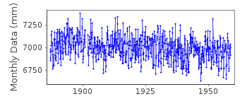
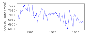
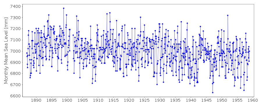
Station Information
| Station ID: | 2133 |
| Latitude: | 57.716667 |
| Longitude: | 11.966667 |
| Coastline code: | 50 |
| Station code: | 30 |
| Country: | SWEDEN |
| Time span of data: | 1887 – 1958 |
| Completeness (%): | 99 |
| Date of last update: | 01 Nov 2012 |
| Green Arrow: | Current Station |
| Yellow Marker: | Neighbouring RLR Station |
| Red Marker: | Neighbouring Metric Station |
Please note: In many cases, the station position in our database is accurate to only one minute. Thus, the tide gauge may not appear to be on the coast.
Tide Gauge Data
Additional Data Sources (guide to additional data sources)
Nearby GNSS Stations from SONEL: 0KRO, 1BAG, 0BRU, 0BIS, 0FRLNearby Real Time Stations from VLIZ: goti, goag, goer, gohi, tang
Station Documentation
Link to RLR information.Documentation - date unknown
These data values are derived from daily observations only.Data prior to 1902 are unreliable as the zero point was not stable.
Documentation added 2012-03-21
Previously the data values for Goteborg-Ringon were included with those forGoteborg-Klippan. However, the SMHI treat the two stations separately. A
decision was made to mirror the SMHI website and separate the two datasets.
Goteborg-Ringon is an historic station last data 1958
Data Authority
Swedish Met. and Hyd. InstituteBox 923
S601 76 Norrkoping

![]()
![]()
![]()
