Data
- Obtaining
- Supplying
- High-Frequency
- Bottom Pressure Records
- Other Long Records
- GLOSS/ODINAFRICA Calibration Data
Donate
Donate to PSMSL
Data Notes
- Individual Station Data and Plot Notes
- Referencing the Data Set
- PSMSL Help File
- 2010 Changes to the PSMSL Data Files
Extracted from Database
13 Jul 2026
Station Information
| Station ID: | 2117 |
| Latitude: | 36.1214 |
| Longitude: | -5.43706 |
| Coastline code: | 220 |
| Station code: | 12 |
| Country: | SPAIN |
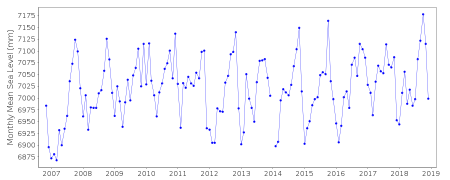
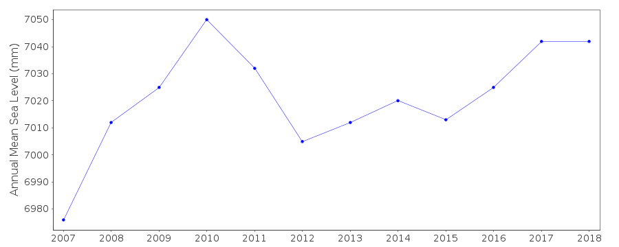
| Time span of data: | 2006 – 2018 |
| Completeness (%): | 93 |
| Date of last update: | 05 Mar 2019 |
| Green Arrow: | Current Station |
| Yellow Marker: | Neighbouring RLR Station |
| Red Marker: | Neighbouring Metric Station |
Please note: In many cases, the station position in our database is accurate to only one minute. Thus, the tide gauge may not appear to be on the coast.
Tide Gauge Data
Additional Data Sources (guide to additional data sources)
Nearby Real Time Stations from VLIZ: alge, gibr3, gibr2Fast Delivery Data from UHSLC station 289: hourly and daily
Research Quality Data from UHSLC station 289: hourly and daily
Station Documentation
Link to RLR information.Documentation added 2012-01-19
Algeciras B is a replacement gauge for the former Algeciras tide gauge. Lat. 367.17N Long. 5 26.13W.Data begins in November 2006.
Datum of the gauge is Tide Gauge Zero (TGZ). TGZ is 0.03m below Hidrographic
Zero. Benchmark details are:
TGBM: border of the protective well
TGZ: 3.520m below TGBM (border of the protective well)
TGZ: 3.895m below Z1 (located in the wall close to the door)
TGZ: 3.499m below Z2 (located in the ground soil in front of the door)
TGZ: 3.666 below NAPG 486 (located in the wall of the former custom-house)
Documentation added 2014-09-03
Using values from a listing recently supplied by the IEO the co-ordinates for Algeciras have been revised.Data Authority
Instituto Español de OceanografíaCorazón de María, 8
28002, Madrid

![]()
![]()
![]()
