Data
- Obtaining
- Supplying
- High-Frequency
- Bottom Pressure Records
- Other Long Records
- GLOSS/ODINAFRICA Calibration Data
Donate
Donate to PSMSL
Data Notes
- Individual Station Data and Plot Notes
- Referencing the Data Set
- PSMSL Help File
- 2010 Changes to the PSMSL Data Files
Extracted from Database
13 Jul 2026
Station Information
| Station ID: | 2084 |
| Latitude: | 40.842206 |
| Longitude: | 8.403914 |
| Coastline code: | 240 |
| Station code: | 6 |
| Country: | ITALY |
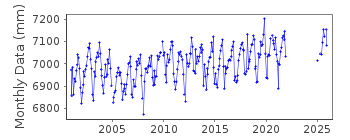
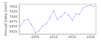
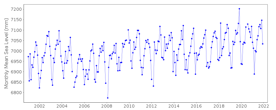
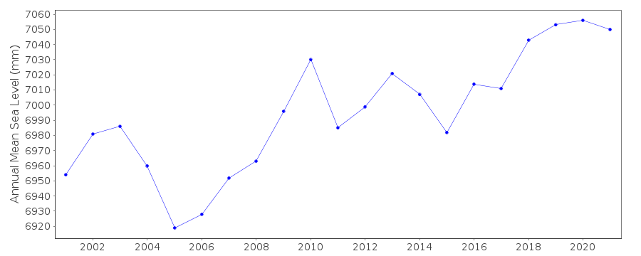
| Time span of data: | 2001 – 2025 |
| Completeness (%): | 85 |
| Date of last update: | 08 May 2026 |
| Green Arrow: | Current Station |
| Yellow Marker: | Neighbouring RLR Station |
| Red Marker: | Neighbouring Metric Station |
Please note: In many cases, the station position in our database is accurate to only one minute. Thus, the tide gauge may not appear to be on the coast.
Tide Gauge Data
Additional Data Sources (guide to additional data sources)
Nearby Real Time Stations from VLIZ: PT17Station Documentation
Link to RLR information.Documentation added 2011-11-01
Porto Torres is on the northern coast of Sardinia and is a new station. Database id.2084 data for 2001 onwards was downloaded from the Istituto Superiore per la Protezione e la Ricerca Ambientale (ISPRA) website. Metadata for the station were also extracted.Documentation added 2012-08-02
Porto Torres is now RLR. Primary benchmark Nodale 51D1/19 3.08496m (displayed as 3.085m on diagram) above national Italian Military Geographic Institute (IGM)altimetric datum.Data Authority
Institute for Environmental Protection and ResearchVia Vitaliano
Brancati 48
00144 Roma

![]()
![]()
![]()
