Data
- Obtaining
- Supplying
- High-Frequency
- Bottom Pressure Records
- Other Long Records
- GLOSS/ODINAFRICA Calibration Data
Donate
Donate to PSMSL
Data Notes
- Individual Station Data and Plot Notes
- Referencing the Data Set
- PSMSL Help File
- 2010 Changes to the PSMSL Data Files
Extracted from Database
13 Jul 2026
WARNING: QCFLAG EXISTS. PLEASE READ THE DOCUMENTATION.
Station Information
| Station ID: | 208 |
| Latitude: | 38.338271 |
| Longitude: | -0.477877 |
| Coastline code: | 220 |
| Station code: | 51 |
| Country: | SPAIN |
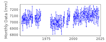
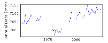
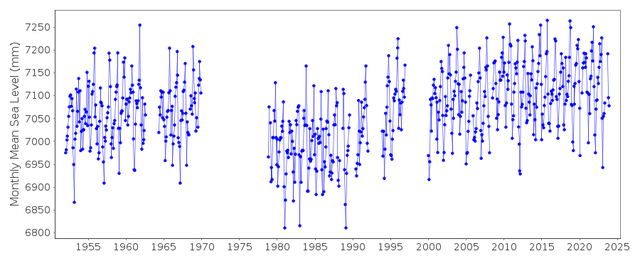
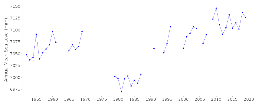
| Time span of RLR data: | 1952 – 2023 |
| RLR completeness (%): | 75 |
| Time span of metric data: | 1916 – 2023 |
| Metric completeness (%): | 70 |
| Link to ellipsoid: | Available |
| Date of last update: | 13 Aug 2024 |
| Green Arrow: | Current Station |
| Yellow Marker: | Neighbouring RLR Station |
| Red Marker: | Neighbouring Metric Station |
Please note: In many cases, the station position in our database is accurate to only one minute. Thus, the tide gauge may not appear to be on the coast.
Tide Gauge Data
Additional Data Sources (guide to additional data sources)
Nearby GNSS Stations from SONEL: ALACNearby Real Time Stations from VLIZ: alac2, alac1
Station Documentation
Link to RLR information.Documentation - date unknown
Apparent datum shift between earlier and later part of the recordDocumentation added 1991-06-11
Alicante 1 RLR(1965) is 10.4m below BM NP1. This tide gauge is situated in the outer harbour area.Data Authority
Instituto Geográfico NacionalRed de Infraestructuras Geodésicas
General Ibáñez de Ibero, 3
28003, Madrid

![]()
![]()
![]()
