Data
- Obtaining
- Supplying
- High-Frequency
- Bottom Pressure Records
- Other Long Records
- GLOSS/ODINAFRICA Calibration Data
Donate
Donate to PSMSL
Data Notes
- Individual Station Data and Plot Notes
- Referencing the Data Set
- PSMSL Help File
- 2010 Changes to the PSMSL Data Files
Extracted from Database
13 Jul 2026
Station Information
| Station ID: | 207 |
| Latitude: | 9.75 |
| Longitude: | 118.733333 |
| Coastline code: | 660 |
| Station code: | 111 |
| Country: | PHILIPPINES |
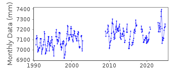
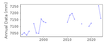
| Time span of RLR data: | 1990 – 2025 |
| RLR completeness (%): | 67 |
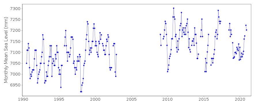
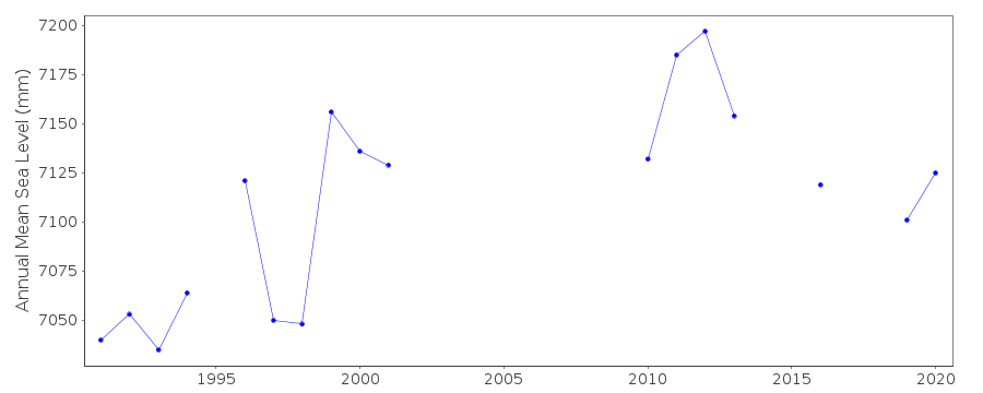
| Time span of metric data: | 1916 – 2025 |
| Metric completeness (%): | 25 |
| Date of last update: | 08 Jul 2026 |
| Green Arrow: | Current Station |
| Yellow Marker: | Neighbouring RLR Station |
| Red Marker: | Neighbouring Metric Station |
Please note: In many cases, the station position in our database is accurate to only one minute. Thus, the tide gauge may not appear to be on the coast.
Tide Gauge Data
Additional Data Sources (guide to additional data sources)
Nearby GNSS Stations from SONEL: PPPCResearch Quality Data from UHSLC station 380: hourly and daily
Station Documentation
Link to RLR information.Documentation added 1993-07-12
Puerto Princesa 660/111 RLR(1992) is 9.7m below BM 1Documentation added 1999-03-30
Gauge type = OttDocumentation added 2010-10-20
Previous data for this station was for 2002. Datum is referred to TSO 1990 with Primary benchmark BM 1.Previously the relationship between benchmark and datum was 4.4m. For 2009 data this is now 4.408m. Gauge type is THALIMEDESDocumentation added 2016-01-07
The datum value from the gauges reinstatement in 2009 is currently being queried. Please treat this data with caution.Data Authority
National Mapping and Resource Information AuthorityHydrography Department
421 Barraca St,
San Nicolas 1010
Manila

![]()
![]()
![]()
