Data
- Obtaining
- Supplying
- High-Frequency
- Bottom Pressure Records
- Other Long Records
- GLOSS/ODINAFRICA Calibration Data
Donate
Donate to PSMSL
Data Notes
- Individual Station Data and Plot Notes
- Referencing the Data Set
- PSMSL Help File
- 2010 Changes to the PSMSL Data Files
Extracted from Database
20 Jul 2026
Station Information
| Station ID: | 2055 |
| Latitude: | 36.177 |
| Longitude: | -5.39838 |
| Coastline code: | 220 |
| Station code: | 15 |
| Country: | SPAIN |
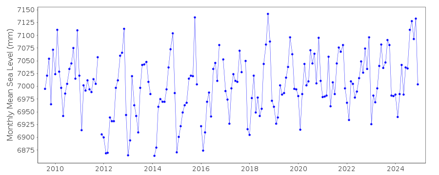
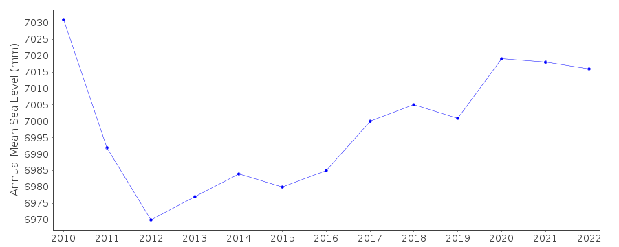
| Time span of data: | 2009 – 2025 |
| Completeness (%): | 93 |
| Date of last update: | 17 Jul 2026 |
| Green Arrow: | Current Station |
| Yellow Marker: | Neighbouring RLR Station |
| Red Marker: | Neighbouring Metric Station |
Please note: In many cases, the station position in our database is accurate to only one minute. Thus, the tide gauge may not appear to be on the coast.
Tide Gauge Data
Additional Data Sources (guide to additional data sources)
Nearby Real Time Stations from VLIZ: alge, gibr3, gibr2Fast Delivery Data from UHSLC station 289: hourly and daily
Research Quality Data from UHSLC station 289: hourly and daily
Station Documentation
Link to RLR information.Documentation added 2011-01-24
Algeciras 2 is a new station first data 2009 and is part of the new REDMAR network.Gauge is a MIROS radar sensor. Initially hardware problems (de-lamination) were
encountered. Also there was a change of -14.3cm to the datum from Jan. 2010 these have been
accounted for in the supplied data. Benchmark NGAB-MAR CEPSA is 3.297m relative
to REDMAR datum and 2.776m relative to IGN. See paper B. Perezet al
'Overlapping sea level time series measured using different technologies:
an example from the REDMAR Spanish network'.
Documentation added 2014-04-29
At the request of Puertos del Estado the latitude and longitude have been revised from 36.176667 -5.398333 derived from the previously supplied degrees and minutes value to 36.17700 -5.39838 the site of the new MIROS gauge in decimal degrees.Data Authority
Puertos del EstadoÁrea de Conocimiento y Análisis del Medio Físico
Avda. Del Partenón, 10
28042, Madrid
Documentation added 2001-03-06
The Area de Conocimiento y Analisis del Medio Fisico wasformerly known as the Departamento de Clima Maritimo.

![]()
![]()
![]()
