Data
- Obtaining
- Supplying
- High-Frequency
- Bottom Pressure Records
- Other Long Records
- GLOSS/ODINAFRICA Calibration Data
Donate
Donate to PSMSL
Data Notes
- Individual Station Data and Plot Notes
- Referencing the Data Set
- PSMSL Help File
- 2010 Changes to the PSMSL Data Files
Extracted from Database
13 Jul 2026
Station Information
| Station ID: | 2047 |
| Latitude: | 37.331074 |
| Longitude: | -5.995795 |
| Coastline code: | 220 |
| Station code: | 10 |
| Country: | SPAIN |
| Time span of data: | 1992 – 2010 |
| Completeness (%): | 89 |
| Date of last update: | 17 Apr 2013 |
| Green Arrow: | Current Station |
| Yellow Marker: | Neighbouring RLR Station |
| Red Marker: | Neighbouring Metric Station |
Please note: In many cases, the station position in our database is accurate to only one minute. Thus, the tide gauge may not appear to be on the coast.
Tide Gauge Data
Additional Data Sources (guide to additional data sources)
Nearby Real Time Stations from VLIZ: sev2Station Documentation
Link to RLR information.Documentation added 2011-01-24
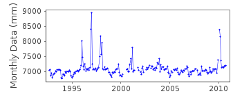
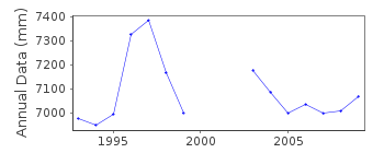
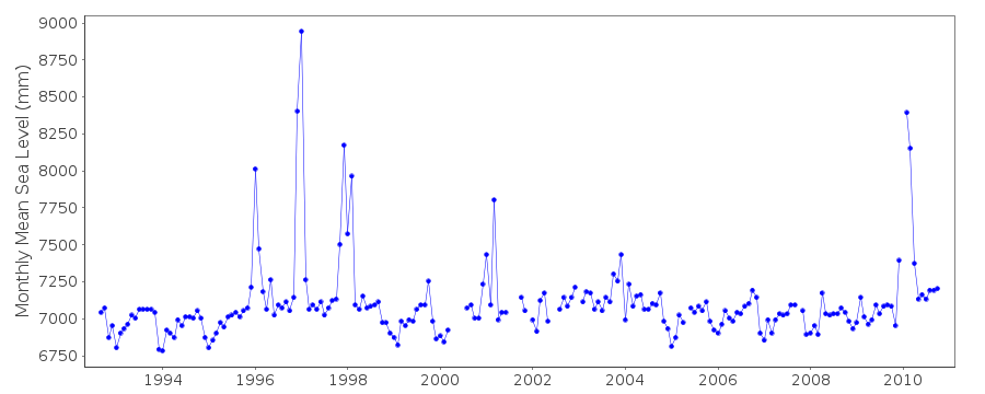
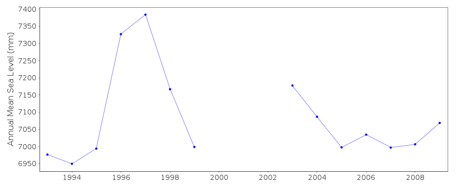
Seville is a new station first data 1992. Gauge is a MIROS radar sensorAlthough data has previously been supplied we have only now received the
latitude and longitude. Benchmark name is JPS 9.026m above datum REDMAR and
8.477m above IGN. See paper B.Perez et al 'Overlapping sea level time series
measured using different technologies: an example from the REDMAR Spanish network'.
Data Authority
Puertos del EstadoÁrea de Conocimiento y Análisis del Medio Físico
Avda. Del Partenón, 10
28042, Madrid
Documentation added 2001-03-06
The Area de Conocimiento y Analisis del Medio Fisico wasformerly known as the Departamento de Clima Maritimo.

![]()
![]()
![]()
