Data
- Obtaining
- Supplying
- High-Frequency
- Bottom Pressure Records
- Other Long Records
- GLOSS/ODINAFRICA Calibration Data
Donate
Donate to PSMSL
Data Notes
- Individual Station Data and Plot Notes
- Referencing the Data Set
- PSMSL Help File
- 2010 Changes to the PSMSL Data Files
Extracted from Database
20 Jul 2026
Station Information
| Station ID: | 2034 |
| Latitude: | 1.312327 |
| Longitude: | 103.988353 |
| Coastline code: | 555 |
| Station code: | 30 |
| Country: | SINGAPORE |
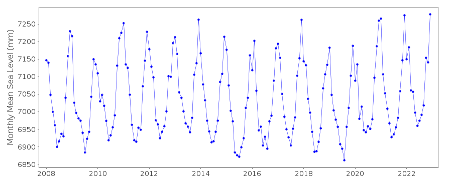
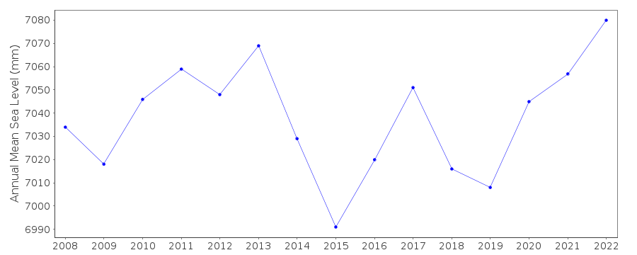
| Time span of data: | 2008 – 2022 |
| Completeness (%): | 100 |
| Date of last update: | 24 Apr 2023 |
| Green Arrow: | Current Station |
| Yellow Marker: | Neighbouring RLR Station |
| Red Marker: | Neighbouring Metric Station |
Please note: In many cases, the station position in our database is accurate to only one minute. Thus, the tide gauge may not appear to be on the coast.
Tide Gauge Data
Station Documentation
Link to RLR information.Documentation added 2010-10-12
Tanah Merah is a new station. First data 2008. TGBM is CUT MARK 4.415m aboveACD. Tanah Merah is now RLR with an RLR year of 2008. RLR factor is 5.385m.
Data Authority
Maritime Port Authority of SingaporeHydrographic Department
460 Alexandra Road, PSA Building
#20-00 Singapore 119963

![]()
![]()
![]()
