Data
- Obtaining
- Supplying
- High-Frequency
- Bottom Pressure Records
- Other Long Records
- GLOSS/ODINAFRICA Calibration Data
Donate
Donate to PSMSL
Data Notes
- Individual Station Data and Plot Notes
- Referencing the Data Set
- PSMSL Help File
- 2010 Changes to the PSMSL Data Files
Extracted from Database
13 Jul 2026
Station Information
| Station ID: | 2024 |
| Latitude: | 32.651111 |
| Longitude: | -17.117778 |
| GLOSS ID: | 250 |
| Coastline code: | 365 |
| Station code: | 10 |
| Country: | PORTUGAL |
| Time span of data: | 2003 – 2015 |
| Completeness (%): | 79 |
| Date of last update: | 06 Jun 2017 |
| Green Arrow: | Current Station |
| Yellow Marker: | Neighbouring RLR Station |
| Red Marker: | Neighbouring Metric Station |
Please note: In many cases, the station position in our database is accurate to only one minute. Thus, the tide gauge may not appear to be on the coast.
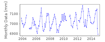
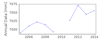
Tide Gauge Data
Station Documentation
Link to RLR information.Documentation added 2010-07-12
Funchal II is a new station. Due to harbour construction the previous tide gauge was giving bad data results. The new gauge is levelled into a new TGBM and so cannot be added to the previous dataset.Documentation added 2010-07-20
This station has now been made RLR. RLR year is 2006 with RLR factor 5.421m. RLR (2006) is 9.5m below TGBM BH 20/02.Documentation added 2017-06-06
The PSMSL has been informed that there were major problems with the Funchal tide gauge (THALES) during 2015.Data Authority
Hydrographic InstituteRua das Trinas 49
1249-093 Lisboa

![]()
![]()
![]()
