Data
- Obtaining
- Supplying
- High-Frequency
- Bottom Pressure Records
- Other Long Records
- GLOSS/ODINAFRICA Calibration Data
Donate
Donate to PSMSL
Data Notes
- Individual Station Data and Plot Notes
- Referencing the Data Set
- PSMSL Help File
- 2010 Changes to the PSMSL Data Files
Extracted from Database
20 Jul 2026
Station Information
| Station ID: | 193 |
| Latitude: | 49.333333 |
| Longitude: | -123.25 |
| Coastline code: | 822 |
| Station code: | 51 |
| Country: | CANADA |
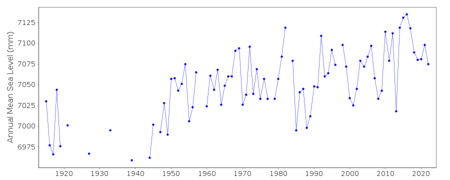
| Time span of data: | 1914 – 2024 |
| Completeness (%): | 80 |
| Date of last update: | 19 Jun 2025 |
| Green Arrow: | Current Station |
| Yellow Marker: | Neighbouring RLR Station |
| Red Marker: | Neighbouring Metric Station |
Please note: In many cases, the station position in our database is accurate to only one minute. Thus, the tide gauge may not appear to be on the coast.
Tide Gauge Data

Station Documentation
Link to RLR information.Documentation added 1994-03-23
Data up to 1991 revised, March 1994Documentation added 1994-07-15
Point Atkinson 822/051 RLR(1991) is 10.9m below BM 213-J-3Documentation added 2011-09-07
Using data from FIsheries and Oceans Canada the RLR diagram has been updated. Primary benchmark remains 213-J-3 previous value was 6.936m above TGZ present value is 6.937m above TGZ. RLR diagram was left as before. Benchmark last inspected in 2006.Documentation added 2015-07-27
This year, rather than just sending the latest year of data, the complete dataset has been supplied. This has highlighted some differences in the data. From communications in the correspondence file for 2002 it appears that the Oceans and Fisheries meant to supply revised data for the stations supplied. This did not happen. The complete dataset includes these data revisions. Therefore, the whole dataset has now been re-entered.Documentation added 2015-07-30
Historic data was included in the above complete dataset. The datum for the period 1915-1945 is currently being queried. Until the Fisheries and Oceans Canada confirm the datum this data has been made Metric.Documentation added 2016-06-28
Datum for the station has been confirmed. It has also been confirmed that from January 1967 the Chart Datum was lowered by 396mm (1.3ft). As the whole dataset was re-loaded this adjustment was already made. The historic data have now been added to the RLR dataset.Documentation added 2018-07-25
Referring to the comment of 2011 the RLR diagram has now been modified so the benchmark is displayed as 6.937m above the datum.Data Authority
Canadian Hydrographic Service615 Booth Street
Ottawa
Ontario K1A 0E6

![]()
![]()
![]()
