Data
- Obtaining
- Supplying
- High-Frequency
- Bottom Pressure Records
- Other Long Records
- GLOSS/ODINAFRICA Calibration Data
Donate
Donate to PSMSL
Data Notes
- Individual Station Data and Plot Notes
- Referencing the Data Set
- PSMSL Help File
- 2010 Changes to the PSMSL Data Files
Extracted from Database
20 Jul 2026
Station Information
| Station ID: | 1929 |
| Latitude: | 41.922798 |
| Longitude: | 8.76285 |
| Coastline code: | 232 |
| Station code: | 1 |
| Country: | FRANCE |
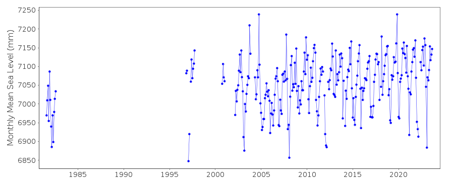
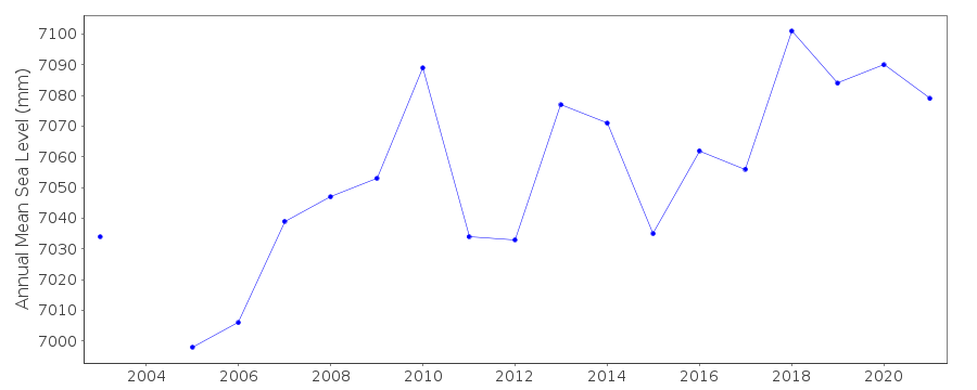
| Time span of data: | 1981 – 2025 |
| Completeness (%): | 54 |
| Link to ellipsoid: | Available |
| Date of last update: | 20 Feb 2026 |
| Green Arrow: | Current Station |
| Yellow Marker: | Neighbouring RLR Station |
| Red Marker: | Neighbouring Metric Station |
Please note: In many cases, the station position in our database is accurate to only one minute. Thus, the tide gauge may not appear to be on the coast.
Tide Gauge Data
Additional Data Sources (guide to additional data sources)
Nearby GNSS Stations from SONEL: AJAC, CAMPNearby Real Time Stations from VLIZ: ajac2, ajac
Station Documentation
Link to RLR information.Documentation added 2007-10-04
Data for Ajaccio Corsica has been added to the PSMSL database.Documentation added 2012-03-28
Ajaccio Corsica is an RLR station. Primary benchmark is IGN FM-5 which is 2.905m above the Hydrographique Zero (TGZ)Documentation added 2014-09-29
The data downloaded from the SONEL website contained additional historic data. The complete dataset has been entered onto the database. Most of the values are identical or 1mm different.Documentation added 2025-07-15
Updated the whole dataset to ensure they include all the historical data recovered recently by SHOM and the calculated monthly and annual means match those distributed by SONEL.Data Authority
SHOM13 rue de Chatelier
29200 BREST

![]()
![]()
![]()
