Data
- Obtaining
- Supplying
- High-Frequency
- Bottom Pressure Records
- Other Long Records
- GLOSS/ODINAFRICA Calibration Data
Donate
Donate to PSMSL
Data Notes
- Individual Station Data and Plot Notes
- Referencing the Data Set
- PSMSL Help File
- 2010 Changes to the PSMSL Data Files
Extracted from Database
13 Jul 2026
Station Information
| Station ID: | 1914 |
| Latitude: | 16.75 |
| Longitude: | -22.983333 |
| GLOSS ID: | 329 |
| Coastline code: | 380 |
| Station code: | 21 |
| Country: | CAPE VERDE |
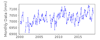
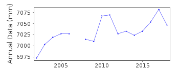
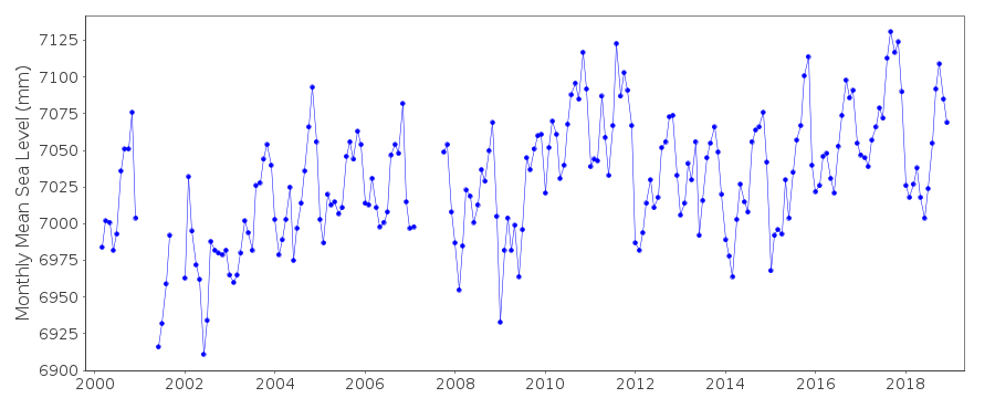
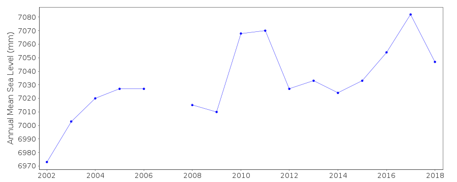
| Time span of data: | 2000 – 2018 |
| Completeness (%): | 93 |
| Link to ellipsoid: | Available |
| Date of last update: | 29 Jan 2020 |
| Green Arrow: | Current Station |
| Yellow Marker: | Neighbouring RLR Station |
| Red Marker: | Neighbouring Metric Station |
Please note: In many cases, the station position in our database is accurate to only one minute. Thus, the tide gauge may not appear to be on the coast.
Tide Gauge Data
Additional Data Sources (guide to additional data sources)
Nearby GNSS Stations from SONEL: CPVG, TGCVNearby Real Time Stations from VLIZ: palm1
Fast Delivery Data from UHSLC station 235: hourly and daily
Research Quality Data from UHSLC station 235: hourly and daily
Station Documentation
Link to RLR information.Documentation added 2010-11-24
Previous data Apr. 2000- Aug. 2001. Complete dataset 2000 - Sept.2010 supplied by UHSLC. Data was checked with previous values before being entered onto the database.Documentation added 2015-11-05
Complete updated JASL data 2000-2014 has been loaded. Datum has been revised from the previous JASL dataset (2000-2010). Using UH levelling information the station has now been made RLR.Data Authority
University of Hawaii Sea Level CenterDepartment of Oceanography Division of Natural Sciences
1000 Pope Road
Honolulu
Hawaii 96822

![]()
![]()
![]()
