Data
- Obtaining
- Supplying
- High-Frequency
- Bottom Pressure Records
- Other Long Records
- GLOSS/ODINAFRICA Calibration Data
Donate
Donate to PSMSL
Data Notes
- Individual Station Data and Plot Notes
- Referencing the Data Set
- PSMSL Help File
- 2010 Changes to the PSMSL Data Files
Extracted from Database
20 Jul 2026
Station Information
| Station ID: | 1907 |
| Latitude: | 39.123642 |
| Longitude: | 23.729475 |
| Coastline code: | 290 |
| Station code: | 37 |
| Country: | GREECE |
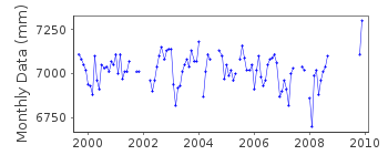
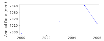
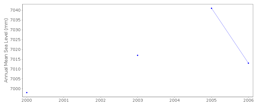
| Time span of data: | 1999 – 2009 |
| Completeness (%): | 73 |
| Date of last update: | 12 Aug 2013 |
| Green Arrow: | Current Station |
| Yellow Marker: | Neighbouring RLR Station |
| Red Marker: | Neighbouring Metric Station |
Please note: In many cases, the station position in our database is accurate to only one minute. Thus, the tide gauge may not appear to be on the coast.
Tide Gauge Data
Station Documentation
Link to RLR information.Documentation added 2000-05-10
Float type gauge , installed 1999. Digitised record.Documentation added 2001-06-04
Skopelos 290/037 RLR(2000) is 8.760m below R69(YY)Documentation added 2013-08-12
Benchmark R 69 YY no longer exists. Benchmark now R 20 0.48m above zero levelDocumentation added 2016-08-02
The supplying authority the Hellenic Navy Hydrographic Service has recently confirmed that the tide gauge at Skopelos is currently out of order due to gauge malfunction.Data Authority
Hellenic Navy Hydrographic ServiceGeographic Policy and International Relations Office
TGN 1040
Athens

![]()
![]()
![]()
