Data
- Obtaining
- Supplying
- High-Frequency
- Bottom Pressure Records
- Other Long Records
- GLOSS/ODINAFRICA Calibration Data
Donate
Donate to PSMSL
Data Notes
- Individual Station Data and Plot Notes
- Referencing the Data Set
- PSMSL Help File
- 2010 Changes to the PSMSL Data Files
Extracted from Database
13 Jul 2026
Station Information
| Station ID: | 190 |
| Latitude: | 56.00593 |
| Longitude: | -2.51688 |
| Coastline code: | 170 |
| Station code: | 41 |
| Country: | UNITED KINGDOM |
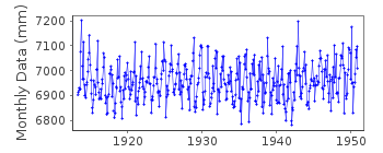
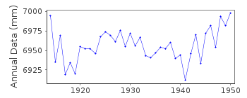
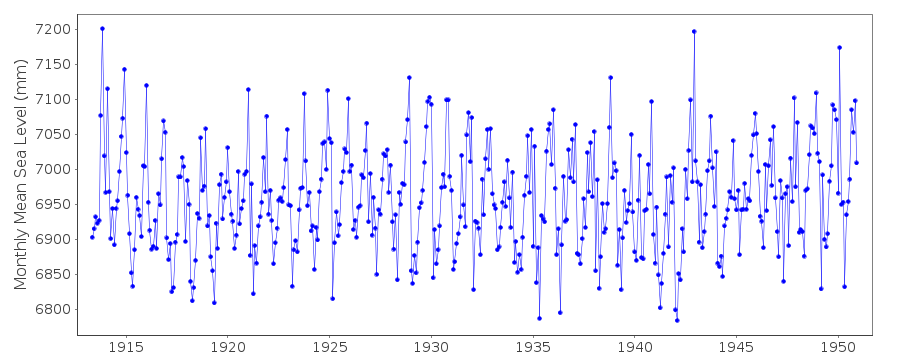
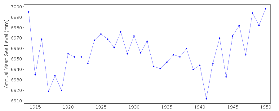
| Time span of RLR data: | 1913 – 1950 |
| RLR completeness (%): | 99 |
| Time span of metric data: | 1913 – 1973 |
| Metric completeness (%): | 63 |
| Date of last update: | 01 Jan 1980 |
| Green Arrow: | Current Station |
| Yellow Marker: | Neighbouring RLR Station |
| Red Marker: | Neighbouring Metric Station |
Please note: In many cases, the station position in our database is accurate to only one minute. Thus, the tide gauge may not appear to be on the coast.
Tide Gauge Data
Station Documentation
Link to RLR information.Documentation added 1991-06-11
Dunbar 170/041 RLR(1950) is 9.3m below BM NT6786 7934Documentation added 1994-07-20
Gauge was maintained and data were processed by the Ordnance Survey.Documentation added 1997-07-22
1913-51: a Carey-Porter gauge functioned continuouslyDocumentation added 1997-09-01
Recording was terminated in 1951 due to increasing siltation.Documentation added 2001-01-02
Recent work on vertical land movements in the UK can be found from the University of Nottingham web site: http://ukcogr.iessg.nottingham.ac.uk/~eosi/Documentation added 2012-03-20
There is a years worth of 'METRIC' data for Jan-Dec 1973. This is the record from a bubbler gauge installed by Doug Leighton and David Pugh in September 1972 and maintained throughout 1973.Dunbar is an historic station last data 1950
Data Authority
British Oceanographic Data CentreNational Oceanography Centre
Joseph Proudman Building, 6 Brownlow Street
Liverpool
L3 5DA

![]()
![]()
![]()
