Data
- Obtaining
- Supplying
- High-Frequency
- Bottom Pressure Records
- Other Long Records
- GLOSS/ODINAFRICA Calibration Data
Donate
Donate to PSMSL
Data Notes
- Individual Station Data and Plot Notes
- Referencing the Data Set
- PSMSL Help File
- 2010 Changes to the PSMSL Data Files
Extracted from Database
20 Jul 2026
Station Information
| Station ID: | 1894 |
| Latitude: | 1.283333 |
| Longitude: | 103.666667 |
| Coastline code: | 555 |
| Station code: | 35 |
| Country: | SINGAPORE |
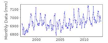
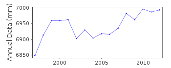
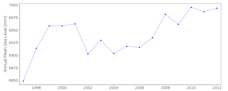
| Time span of data: | 1997 – 2013 |
| Completeness (%): | 98 |
| Date of last update: | 21 Jan 2014 |
| Green Arrow: | Current Station |
| Yellow Marker: | Neighbouring RLR Station |
| Red Marker: | Neighbouring Metric Station |
Please note: In many cases, the station position in our database is accurate to only one minute. Thus, the tide gauge may not appear to be on the coast.
Tide Gauge Data
Additional Data Sources (guide to additional data sources)
Nearby GNSS Stations from SONEL: SGQZ, NTUS, SIN1Station Documentation
Link to RLR information.Documentation added 2010-10-14
Station Tuas (West Jurong) is a separate station to West Tuas. Dataspan of Tuas starts in Jan 1997. Tuas (West Jurong) was made RLR in 2009. RLR year is 2008. Primary benchmark MPA 3 is 4.5m above ACS. RLR (2008) is 9.7m below BM. RLR factor is 5.200m.Documentation added 2014-01-21
The tide gauge at West Jurong was decommissioned in August 2013.Data Authority
Maritime Port Authority of SingaporeHydrographic Department
460 Alexandra Road, PSA Building
#20-00 Singapore 119963

![]()
![]()
![]()
