Data
- Obtaining
- Supplying
- High-Frequency
- Bottom Pressure Records
- Other Long Records
- GLOSS/ODINAFRICA Calibration Data
Donate
Donate to PSMSL
Data Notes
- Individual Station Data and Plot Notes
- Referencing the Data Set
- PSMSL Help File
- 2010 Changes to the PSMSL Data Files
Extracted from Database
13 Jul 2026
Station Information
| Station ID: | 1892 |
| Latitude: | 39.552381 |
| Longitude: | 2.638912 |
| Coastline code: | 225 |
| Station code: | 11 |
| Country: | SPAIN |
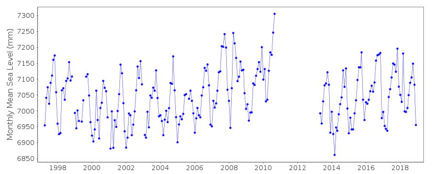
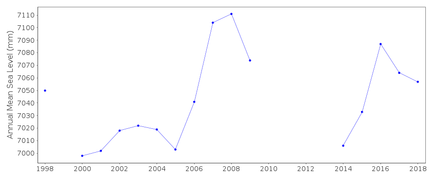
| Time span of data: | 1997 – 2018 |
| Completeness (%): | 85 |
| Link to ellipsoid: | Available |
| Date of last update: | 05 Mar 2019 |
| Green Arrow: | Current Station |
| Yellow Marker: | Neighbouring RLR Station |
| Red Marker: | Neighbouring Metric Station |
Please note: In many cases, the station position in our database is accurate to only one minute. Thus, the tide gauge may not appear to be on the coast.
Tide Gauge Data
Additional Data Sources (guide to additional data sources)
Nearby GNSS Stations from SONEL: MAL1, MALLNearby Real Time Stations from VLIZ: palm
Station Documentation
Link to RLR information.Documentation added 2008-12-04
revised values for Palmas de Mallorca entered following listing from Maria Jesus. Previous values downloaded and put in file.rlrfac is 6.32m
RLR (2000) is 9.6 below BM Clavo Mfo
Documentation added 2014-09-03
Using values from a listing recently supplied by IEO the co-ordinates for Palma de Mallorca have been revised.Documentation added 2016-01-12
Revised data values have been received from IEO for Palma de Mallorca for 2010, 2013 and 2014. The revised data values have now been entered onto the database.Data Authority
Instituto Español de OceanografíaCorazón de María, 8
28002, Madrid

![]()
![]()
![]()
