Data
- Obtaining
- Supplying
- High-Frequency
- Bottom Pressure Records
- Other Long Records
- GLOSS/ODINAFRICA Calibration Data
Donate
Donate to PSMSL
Data Notes
- Individual Station Data and Plot Notes
- Referencing the Data Set
- PSMSL Help File
- 2010 Changes to the PSMSL Data Files
Extracted from Database
20 Jul 2026
Station Information
| Station ID: | 1887 |
| Latitude: | 20.683333 |
| Longitude: | 58.866667 |
| Coastline code: | 487 |
| Station code: | 12 |
| Country: | OMAN |
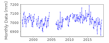
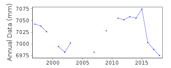
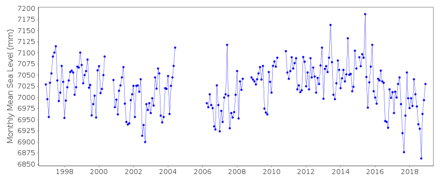
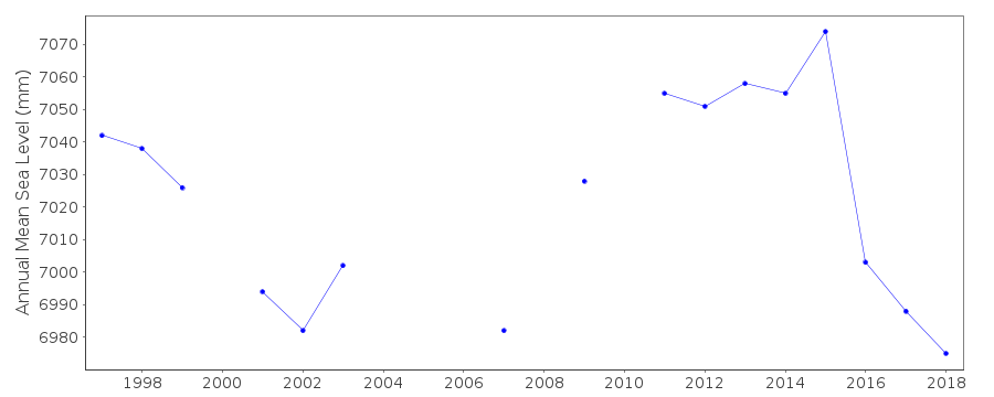
| Time span of data: | 1996 – 2018 |
| Completeness (%): | 83 |
| Date of last update: | 29 Jan 2020 |
| Green Arrow: | Current Station |
| Yellow Marker: | Neighbouring RLR Station |
| Red Marker: | Neighbouring Metric Station |
Please note: In many cases, the station position in our database is accurate to only one minute. Thus, the tide gauge may not appear to be on the coast.
Tide Gauge Data
Additional Data Sources (guide to additional data sources)
Nearby Real Time Stations from VLIZ: masi2Fast Delivery Data from UHSLC station 113: hourly and daily
Research Quality Data from UHSLC station 113: hourly and daily
Station Documentation
Link to RLR information.Documentation added 2010-11-18
Previous dataset ended in Oct. 2003. Complete dataset 1996-2008 supplied by the previous authority UHSLC. These were checked against existing data values and were then loaded onto the database.Documentation added 2013-10-15
Complete UHSLC dataset 1996-2012 added several values had been revised from the previous dataset.Documentation added 2015-10-29
Complete updated UHSLC dataset has been reloaded. Using the UHSLC levelling information the station has been made RLR. Primary Benchmark is UH 1 5.648m above the gauge Datum.Data Authority
University of Hawaii Sea Level CenterDepartment of Oceanography Division of Natural Sciences
1000 Pope Road
Honolulu
Hawaii 96822

![]()
![]()
![]()
