Data
- Obtaining
- Supplying
- High-Frequency
- Bottom Pressure Records
- Other Long Records
- GLOSS/ODINAFRICA Calibration Data
Donate
Donate to PSMSL
Data Notes
- Individual Station Data and Plot Notes
- Referencing the Data Set
- PSMSL Help File
- 2010 Changes to the PSMSL Data Files
Extracted from Database
13 Jul 2026
Station Information
| Station ID: | 188 |
| Latitude: | 24.555 |
| Longitude: | -81.806667 |
| GLOSS ID: | 216 |
| Coastline code: | 940 |
| Station code: | 71 |
| Country: | UNITED STATES |
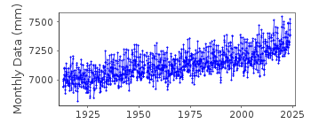
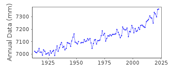
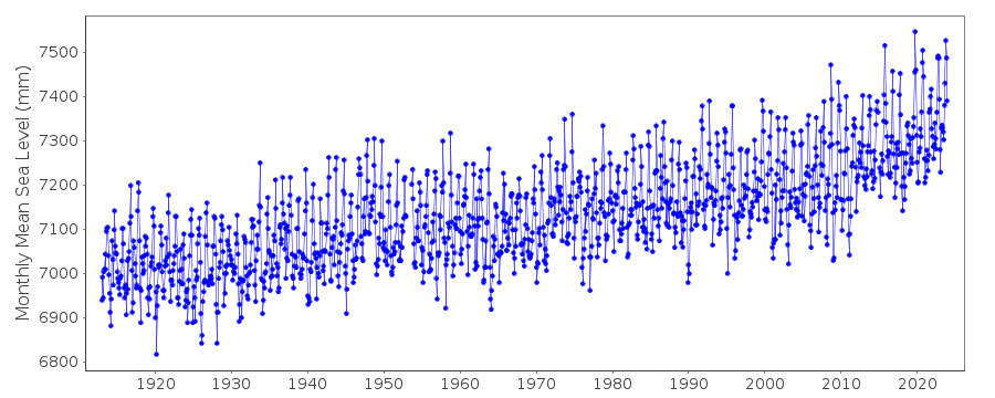
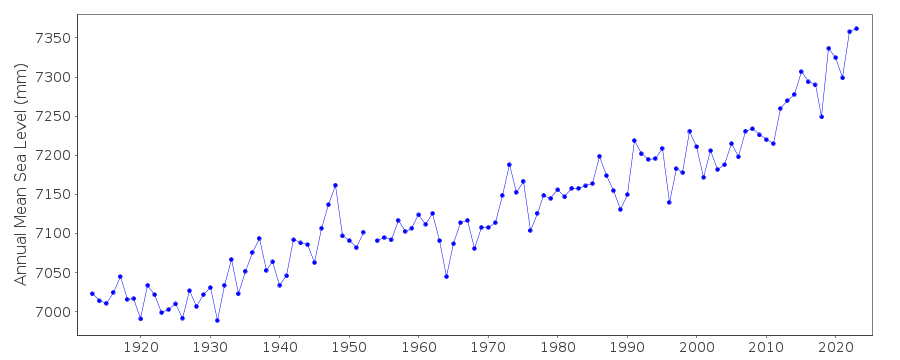
| Time span of data: | 1913 – 2025 |
| Completeness (%): | 99 |
| Date of last update: | 27 Jan 2026 |
| Green Arrow: | Current Station |
| Yellow Marker: | Neighbouring RLR Station |
| Red Marker: | Neighbouring Metric Station |
Please note: In many cases, the station position in our database is accurate to only one minute. Thus, the tide gauge may not appear to be on the coast.
Tide Gauge Data
Additional Data Sources (guide to additional data sources)
Nearby GNSS Stations from SONEL: KYW5, KWST, KYW1, CHINNearby Real Time Stations from VLIZ: kwfl
Fast Delivery Data from UHSLC station 242: hourly and daily
Research Quality Data from UHSLC station 242: hourly and daily
Station Documentation
Link to RLR information.Documentation added 1991-06-11
Key West 940/071 RLR(1964) is 9.5m below BM29Documentation added 1993-07-29
Many stations on the Gulf coast have large values for September 1961.Documentation added 1994-07-12
For a description of Key West data dating back to 1846, see MAUL, G.A. & MARTIN, D.M. 1993, Sea level rise at Key West, Florida, 1846-1992: America's longest instrument record?Geophysical Research Letters, 20(18), 1955-1958.
Documentation added 2011-07-27
Data is downloaded directly from the NOAA website. Datum information also downloaded. The NOAA Primary Benchmark is 4580 E 1998 3.116m above TGZ.Data Authority
N.O.A.A. / N.O.S.N/oes33, Ssmc4, Room 6531
1305 East-West Highway
Silver Spring,
MD 20910

![]()
![]()
![]()
