Data
- Obtaining
- Supplying
- High-Frequency
- Bottom Pressure Records
- Other Long Records
- GLOSS/ODINAFRICA Calibration Data
Donate
Donate to PSMSL
Data Notes
- Individual Station Data and Plot Notes
- Referencing the Data Set
- PSMSL Help File
- 2010 Changes to the PSMSL Data Files
Extracted from Database
20 Jul 2026
Station Information
| Station ID: | 1871 |
| Latitude: | 43.55803 |
| Longitude: | -5.69835 |
| Coastline code: | 200 |
| Station code: | 22 |
| Country: | SPAIN |
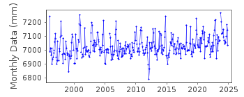
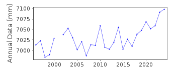
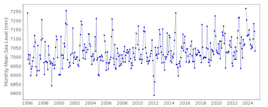
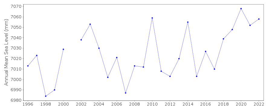
| Time span of data: | 1996 – 2025 |
| Completeness (%): | 97 |
| Link to ellipsoid: | Available |
| Date of last update: | 17 Jul 2026 |
| Green Arrow: | Current Station |
| Yellow Marker: | Neighbouring RLR Station |
| Red Marker: | Neighbouring Metric Station |
Please note: In many cases, the station position in our database is accurate to only one minute. Thus, the tide gauge may not appear to be on the coast.
Tide Gauge Data
Additional Data Sources (guide to additional data sources)
Nearby GNSS Stations from SONEL: XIXO, XIX1Nearby Real Time Stations from VLIZ: gij2
Station Documentation
Link to RLR information.Documentation added 1999-08-20
Gauge type=SONAR acousticDocumentation added 2000-04-25
Gijon II 200/022 RLR(1996) is 10.3m below BM NGU 83Documentation added 2005-05-23
A paper by Marcos et al (JGR Volume 11, 2005) provides an overview of the tide gauge records on the northern coast of Spain.Documentation added 2011-01-27
Previously dataset ended in December 2005. Full dataset 1995 - 2009 received from Begona at PE. In both there was no data value for September 2005. The new version of the data was 7cm higher than that previously held in the database. When queried with Begona she said a datum shift had been detected and the newly supplied data was the correct version. Complete dataset was re-entered onto the database.Documentation added 2013-04-10
The old SRD acoustic gauge at Gijon has been replaced by a new MIROS radar gauge. Both old and new gauges were running for the period 8.02.2008-1.07.2008 for inter- comparison purposes. A bias (mean difference) between the two gauges of -2.55cm was calculated. The new MIROS gauge suffered some hardware faults (de-lamination) which were later corrected. The PSMSL were instructed by Begona Perez of PEto discard the data for 2008/9 as problems were encountered. See paper B. Perez et al 'Overlapping sea level time series measured using different technologies: an example from the REDMAR Spanish network'.Documentation added 2014-01-13
Further investigatuion from Puertos del Estado has revealed that the bias between old and new datasets indicated an error in the old Acoustic gauge. Data from the old gauge has been revised to account for this. Whole dataset re-entered onto database.Documentation added 2014-04-28
At the request of Puertos del Estado the latitude and longitude have been changed from 43.566667 -5.500000 which is the value derived from the previously supplied degrees and minutes listing to 43.55803 -5.69835 the co-ordintes for the new MIROS gauge.Data Authority
Puertos del EstadoÁrea de Conocimiento y Análisis del Medio Físico
Avda. Del Partenón, 10
28042, Madrid
Documentation added 2001-03-06
The Area de Conocimiento y Analisis del Medio Fisico wasformerly known as the Departamento de Clima Maritimo.

![]()
![]()
![]()
