Data
- Obtaining
- Supplying
- High-Frequency
- Bottom Pressure Records
- Other Long Records
- GLOSS/ODINAFRICA Calibration Data
Donate
Donate to PSMSL
Data Notes
- Individual Station Data and Plot Notes
- Referencing the Data Set
- PSMSL Help File
- 2010 Changes to the PSMSL Data Files
Extracted from Database
13 Jul 2026
Station Information
| Station ID: | 1855 |
| Latitude: | 49.917861 |
| Longitude: | -6.317222 |
| Coastline code: | 170 |
| Station code: | 163 |
| Country: | UNITED KINGDOM |
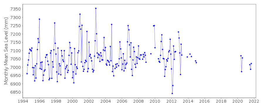
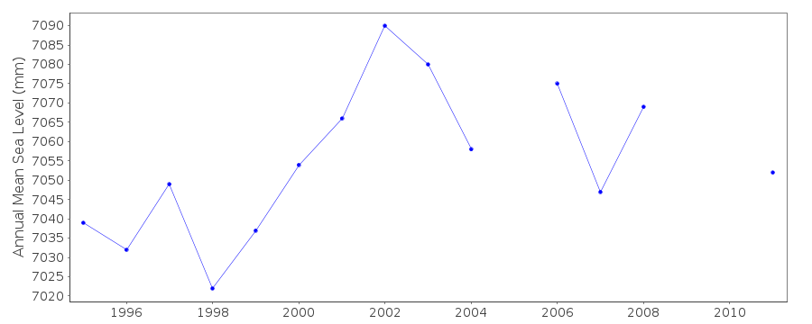
| Time span of data: | 1994 – 2021 |
| Completeness (%): | 65 |
| Date of last update: | 19 Feb 2026 |
| Green Arrow: | Current Station |
| Yellow Marker: | Neighbouring RLR Station |
| Red Marker: | Neighbouring Metric Station |
Please note: In many cases, the station position in our database is accurate to only one minute. Thus, the tide gauge may not appear to be on the coast.
Tide Gauge Data
Additional Data Sources (guide to additional data sources)
Nearby GNSS Stations from SONEL: SCILNearby Real Time Stations from VLIZ: stmr
Station Documentation
Link to RLR information.Documentation added 2000-04-25
St. Mary's 170/163 RLR(1997) is 11.3m below TGBM boltDocumentation added 2001-01-02
Recent work on vertical land movements in the UK can be found fromthe University of Nottingham web site:
http://ukcogr.iessg.nottingham.ac.uk/~eosi/
Documentation added 2012-12-13
Possibly due to rounding the annual mean for the RLR year 1997 is 3.174m in thedatabase.As a result the RLR factor has changed from 3.876m to 3.875m and the
height of MSL to RLR has changed from 7.05m to 7.049m.
Documentation added 2015-06-02
There were problems with pressure loss throughout the year with readings >60mm low in places. TGI were at site 27.09.14 to carry out general maintenance and survey the site for a new tide gauge once harbour works have been completed.Data Authority
Environment AgencyHorizon House
Deanery Road
BS1 5AH
Bristol

![]()
![]()
![]()
