Data
- Obtaining
- Supplying
- High-Frequency
- Bottom Pressure Records
- Other Long Records
- GLOSS/ODINAFRICA Calibration Data
Donate
Donate to PSMSL
Data Notes
- Individual Station Data and Plot Notes
- Referencing the Data Set
- PSMSL Help File
- 2010 Changes to the PSMSL Data Files
Extracted from Database
20 Jul 2026
Station Information
| Station ID: | 1854 |
| Latitude: | 53.331667 |
| Longitude: | -3.825222 |
| Coastline code: | 170 |
| Station code: | 196 |
| Country: | UNITED KINGDOM |
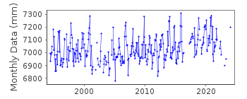
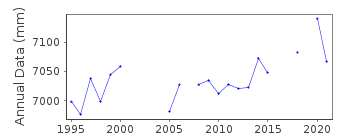
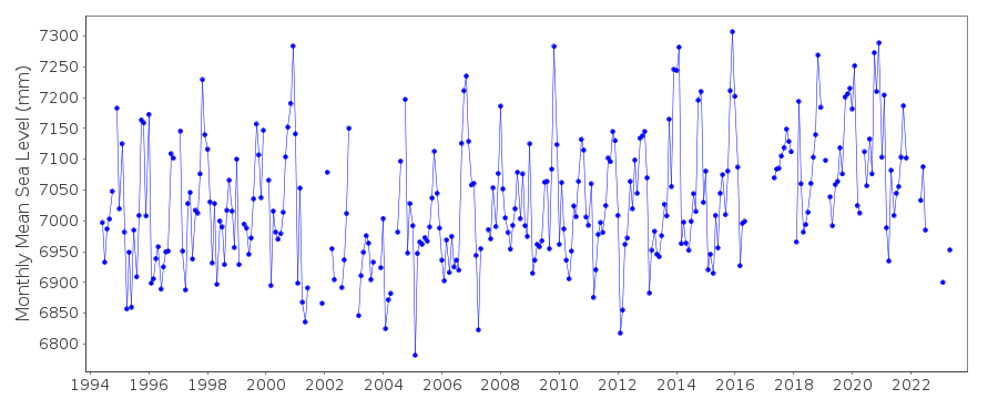
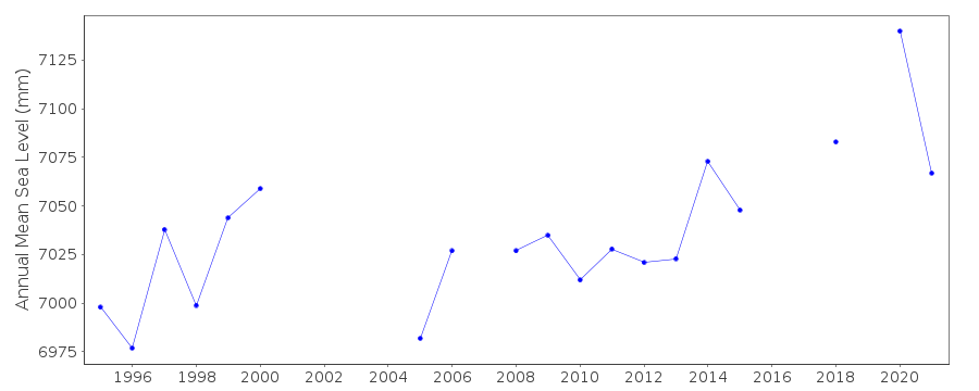
| Time span of data: | 1994 – 2024 |
| Completeness (%): | 80 |
| Date of last update: | 19 Feb 2025 |
| Green Arrow: | Current Station |
| Yellow Marker: | Neighbouring RLR Station |
| Red Marker: | Neighbouring Metric Station |
Please note: In many cases, the station position in our database is accurate to only one minute. Thus, the tide gauge may not appear to be on the coast.
Tide Gauge Data
Additional Data Sources (guide to additional data sources)
Nearby Real Time Stations from VLIZ: llanStation Documentation
Link to RLR information.Documentation added 2001-01-02
Recent work on vertical land movements in the UK can be found fromthe University of Nottingham web site:
http://ukcogr.iessg.nottingham.ac.uk/~eosi/
Documentation added 2012-05-17
Llandudno has been made an RLR station. Primary benchmark TGBM. TGZ (ACD) is12.558m below TGBM. RLR factor is 2.942m.
Documentation added 2014-07-03
There was some disruption to some high waters during June. There were 2 TGI visits 04.07.2013 for general maintenance to change the compressor and carry out a survey. 19.12.2013 to inspect the site for storm surge damage and investigate a phone line fault.Documentation added 2015-06-02
There were no site visits to Llandudno during 2014.Data Authority
Environment AgencyHorizon House
Deanery Road
BS1 5AH
Bristol

![]()
![]()
![]()
