Data
- Obtaining
- Supplying
- High-Frequency
- Bottom Pressure Records
- Other Long Records
- GLOSS/ODINAFRICA Calibration Data
Donate
Donate to PSMSL
Data Notes
- Individual Station Data and Plot Notes
- Referencing the Data Set
- PSMSL Help File
- 2010 Changes to the PSMSL Data Files
Extracted from Database
13 Jul 2026
Station Information
| Station ID: | 1845 |
| Latitude: | -15.920864 |
| Longitude: | -5.717961 |
| GLOSS ID: | 264 |
| Coastline code: | 425 |
| Station code: | 1 |
| Country: | SAINT HELENA, ASCENSION AND TRISTAN DA CUNHA |
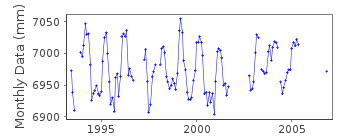
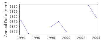
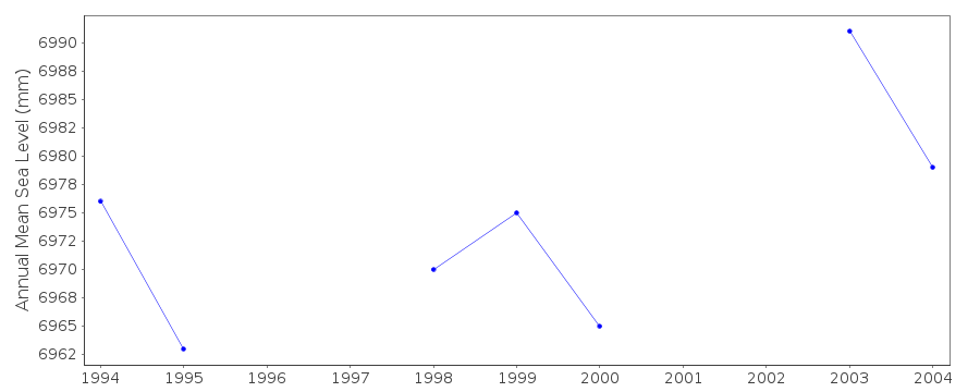
| Time span of RLR data: | 1993 – 2006 |
| RLR completeness (%): | 71 |
| Time span of metric data: | 1993 – 2013 |
| Metric completeness (%): | 58 |
| Date of last update: | 03 Jun 2014 |
| Green Arrow: | Current Station |
| Yellow Marker: | Neighbouring RLR Station |
| Red Marker: | Neighbouring Metric Station |
Please note: In many cases, the station position in our database is accurate to only one minute. Thus, the tide gauge may not appear to be on the coast.
Tide Gauge Data
Additional Data Sources (guide to additional data sources)
Nearby GNSS Stations from SONEL: STHLNearby Real Time Stations from VLIZ: sthl2
Fast Delivery Data from UHSLC station 292: hourly and daily
Research Quality Data from UHSLC station 292: hourly and daily
Station Documentation
Link to RLR information.Documentation added 1998-02-25
The gauge was stopped in October 1996 because of harbour works. A new installation was installed in April 1997Documentation added 2002-09-10
St. Helena gauge failed September 2001.Documentation added 2011-10-05
A revised RLR diagram for Jamestown Landing Steps - St. Helena has been prepared following discussions with Alan Hudson Head of Technical Services on St. HelenaData Authority
British Oceanographic Data CentreNational Oceanography Centre
Joseph Proudman Building, 6 Brownlow Street
Liverpool
L3 5DA

![]()
![]()
![]()
